


A map of the Mediterranean in 218 BC, showing the territorial extents of the following states: - Antigonids - Attalids - Carthage - Ptolemies - Roman Empire - Seleucids Major battle locations are also shown.
Related Images

The Second Punic War (218 - 201 BCE)

Map of the Rise and Fall of Carthage (c. 650-146 BCE)
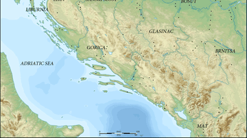
Map of Prehistoric Illyria

Map of the Indus Valley Civilization, c. 3300-1300 BCE
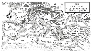
An Illustrated Map of the Mediterranean from 700 BCE to 500 CE (From the Novel "The Jericho River")

Map of the Cradles of Early Civilization - Global Pathways to Agriculture, Urban Centers & Early States
Cite This Work
APA Style
Megistias. (2012, April 26). Map of the Mediterranean 218 BCE. World History Encyclopedia. https://www.worldhistory.org/image/283/map-of-the-mediterranean-218-bce/
Chicago Style
Megistias. "Map of the Mediterranean 218 BCE." World History Encyclopedia, April 26, 2012. https://www.worldhistory.org/image/283/map-of-the-mediterranean-218-bce/.
MLA Style
Megistias. "Map of the Mediterranean 218 BCE." World History Encyclopedia, 26 Apr 2012, https://www.worldhistory.org/image/283/map-of-the-mediterranean-218-bce/.