
Server Costs Fundraiser 2026


A map of the Mediterranean in 218 BC, showing the territorial extents of the following states: - Antigonids - Attalids - Carthage - Ptolemies - Roman Empire - Seleucids Major battle locations are also shown.
Related Images

The Second Punic War (218 - 201 BCE)

Map of the Rise and Fall of Carthage (c. 650-146 BCE)
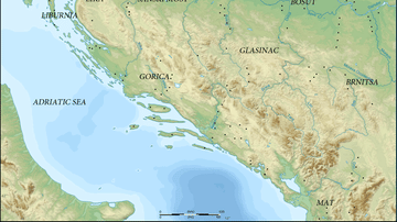
Map of Prehistoric Illyria

Map of the Indus Valley Civilization, c. 3300-1300 BCE - Cities, Trade, and Settlement in the Bronze Age
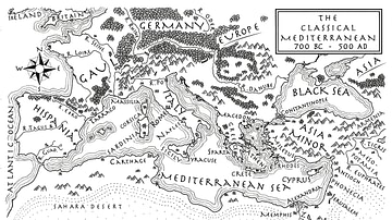
An Illustrated Map of the Mediterranean from 700 BCE to 500 CE (From the Novel "The Jericho River")

Map of the Achaemenid Persian Empire c. 500 BCE
Cite This Work
APA Style
Megistias. (2012, April 26). Map of the Mediterranean 218 BCE. World History Encyclopedia. https://www.worldhistory.org/image/283/map-of-the-mediterranean-218-bce/
Chicago Style
Megistias. "Map of the Mediterranean 218 BCE." World History Encyclopedia, April 26, 2012. https://www.worldhistory.org/image/283/map-of-the-mediterranean-218-bce/.
MLA Style
Megistias. "Map of the Mediterranean 218 BCE." World History Encyclopedia, 26 Apr 2012, https://www.worldhistory.org/image/283/map-of-the-mediterranean-218-bce/.