


This map illustrates the rise and development of the Bosporan Kingdom (c. 480 BCE – 341 CE), a Greco-Scythian state centered on the Bosporus Cimmerius (modern Kerch Strait). Established by Greek colonists from Miletus and other poleis, the kingdom flourished as the longest-lasting of the classical Black Sea states, enduring for more than eight centuries as a major hub of trade and cultural exchange.
The kingdom was first ruled by the Archaeanactid dynasty (c. 480–438 BCE) and then by the powerful Spartocid dynasty (438–110 BCE), which stabilized the realm and turned it into a major exporter of grain, fish, timber, and slaves to mainland Greece, especially Athens. In the late Hellenistic period, the Bosporan kings aligned with Rome; under Mithridates VI of Pontus (120–63 BCE) it briefly came under Pontic control, but by the mid-1st century BCE it was recognized as a Roman client state. Dynasts such as Tiberius Julius Aspurgus (r. 8 BCE–38 CE) inaugurated a line of rulers who combined Greek and local names, reflecting the kingdom’s role as a cultural crossroads, where Greek, Scythian, and later Sarmatian influences mingled. Protected and subsidized by Rome, the Bosporan Kingdom enjoyed prosperity until the 3rd–4th centuries CE, when pressure from Goths, Alans, and ultimately the Huns (c. 370s CE) eroded its stability, leading to its decline and eventual disappearance as an independent state by 341 CE.
About the Author

Related Images

Map of the Roman Trade Network (1st - 3rd centuries CE)

Map of the Hanseatic League Trade Network, c. 1400

Greek and Phoenician Colonization
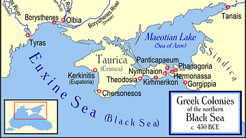
Greek Colonies of the Northern Black Sea

Phoenician Trade Network

Map of a Circumnavigation of the Black Sea c. 130 CE - Arrian of Nicomedia's "Periplus Ponti Euxini"
Cite This Work
APA Style
Netchev, S. (2024, December 10). Map of the Bosporan Kingdom, c.100 CE. World History Encyclopedia. https://www.worldhistory.org/image/19765/map-of-the-bosporan-kingdom-c100-ce/
Chicago Style
Netchev, Simeon. "Map of the Bosporan Kingdom, c.100 CE." World History Encyclopedia, December 10, 2024. https://www.worldhistory.org/image/19765/map-of-the-bosporan-kingdom-c100-ce/.
MLA Style
Netchev, Simeon. "Map of the Bosporan Kingdom, c.100 CE." World History Encyclopedia, 10 Dec 2024, https://www.worldhistory.org/image/19765/map-of-the-bosporan-kingdom-c100-ce/.