


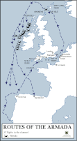
A map illustrating the route and failing fortunes of the Spanish Armada (from Spanish - Grande y Felicísima Armada, “Great and Most Fortunate Fleet”) in 1588. A crucial part of a planned invasion of England by King Philip II of Spain, the Armada was the largest fleet assembled in Europe, made up of more than 130 ships. It was considered invincible. The events of 1588 marked the pinnacle of years of political, religious, and trade friction between Catholic Spain and Protestant Elizabethan England. The English navy’s innovative strategies, the Spanish bad judgment and failed communication, together with unfavorable weather, doomed the enterprise to failure, cemented England’s sovereignty, and had profound consequences for the balance of power in Europe.
About the Author

Related Images
Route Map of the Spanish Armada

Map of Francis Drake's Circumnavigation, 1577-80 CE

Map of Elizabethan Trade with Europe, c. 1600 - Trade and Diplomacy in the Tudor World

Map of Jeanne d'Arc's Route & The Hundred Years' War c. 1429

Map of the Spanish Colonial Empire

Map of Hannibal's Route into Italy
Cite This Work
APA Style
Netchev, S. (2023, September 20). Map of the Route of The Spanish Armada, Jul-Sep 1588. World History Encyclopedia. https://www.worldhistory.org/image/17902/map-of-the-route-of-the-spanish-armada-jul-sep-158/
Chicago Style
Netchev, Simeon. "Map of the Route of The Spanish Armada, Jul-Sep 1588." World History Encyclopedia, September 20, 2023. https://www.worldhistory.org/image/17902/map-of-the-route-of-the-spanish-armada-jul-sep-158/.
MLA Style
Netchev, Simeon. "Map of the Route of The Spanish Armada, Jul-Sep 1588." World History Encyclopedia, 20 Sep 2023, https://www.worldhistory.org/image/17902/map-of-the-route-of-the-spanish-armada-jul-sep-158/.