


This map illustrates the emergence of the Holy Roman Empire in the mid-10th century, following the final division of the Eastern and Western Frankish realms in the late 9th century. Under Otto I (r. as German king 936–973; crowned Holy Roman Emperor 962–973), the empire took shape as a loosely integrated union of German states and cities, bound together by tradition, personal loyalties, mutual obligations, and the suppression of rebellious vassals. Otto extended the German kingdom eastward, made Bohemia a tributary state, assumed the title of King of the Lombards in Italy, and exerted influence from Denmark to Burgundy.
A skilled military leader, Otto decisively defeated the Magyars at the Battle of Lechfeld (955), securing the empire’s eastern frontier. Crowned Imperator Augustus in Rome in 962, he twice deposed popes who opposed him and systematically used the church both as a political tool and as a stabilizing force within his realm. His reign marked the consolidation of the German kingdom and the revival of the imperial title in Western Europe, laying the foundations for the Holy Roman Empire’s role in medieval politics.
About the Author

Related Images

Map of the Holy Roman Empire, 972-1032 CE

Map of the Battle of Verdun

Map of the Roman Empire under Theodosius the Great, c.395 - The Last Unified Roman Empire
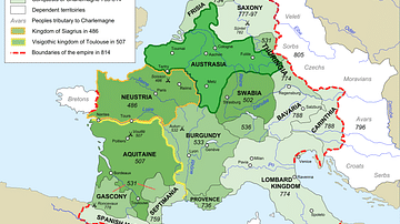
Map of Francia

Map of European Expansion & Mercantile Empires, c. 1700

Map of the Provinces of the Roman Empire under Augustus
Cite This Work
APA Style
Netchev, S. (2022, September 26). Map of the Holy Roman Empire under Otto the Great c. 972. World History Encyclopedia. https://www.worldhistory.org/image/16428/map-of-the-holy-roman-empire-under-otto-the-great/
Chicago Style
Netchev, Simeon. "Map of the Holy Roman Empire under Otto the Great c. 972." World History Encyclopedia, September 26, 2022. https://www.worldhistory.org/image/16428/map-of-the-holy-roman-empire-under-otto-the-great/.
MLA Style
Netchev, Simeon. "Map of the Holy Roman Empire under Otto the Great c. 972." World History Encyclopedia, 26 Sep 2022, https://www.worldhistory.org/image/16428/map-of-the-holy-roman-empire-under-otto-the-great/.