


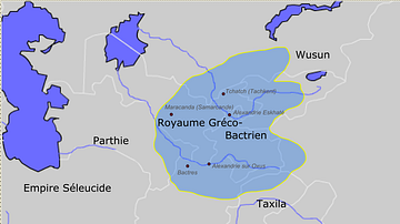
Approximate maximum extent of the Greco-Bactrian kingdom circa 180 BCE, including the regions of Tapuria and Traxiane to the West, Sogdiana and Ferghana to the north, Bactria and Arachosia to the south.
Related Images
Greco-Bactrian kingdom circa 230-200 BC

Map of the Bosporan Kingdom, c.100 CE - Gateway Between Steppe, Caucasus, and Rome

Map of the Ptolemaic Kingdom of Egypt c. 240 BCE - Power, Wealth, and Rivalry in the Hellenistic World
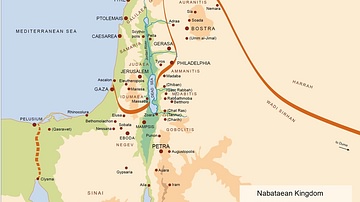
Map of the Nabatean Kingdom

Map of Kingdom of Axum

Map of the Middle Kingdom of Egypt, c. 2000 BCE
Cite This Work
APA Style
PHGCOM. (2012, April 26). Map of the Greco-Bactrian Kingdom. World History Encyclopedia. https://www.worldhistory.org/image/162/map-of-the-greco-bactrian-kingdom/
Chicago Style
PHGCOM. "Map of the Greco-Bactrian Kingdom." World History Encyclopedia, April 26, 2012. https://www.worldhistory.org/image/162/map-of-the-greco-bactrian-kingdom/.
MLA Style
PHGCOM. "Map of the Greco-Bactrian Kingdom." World History Encyclopedia, 26 Apr 2012, https://www.worldhistory.org/image/162/map-of-the-greco-bactrian-kingdom/.