


1598 Map of the Three Arctic Voyages (1594–1596) by Willem Barentsz. Spitsbergen (now Svalbard) is mapped for the first time and indicated as "Het Nieuwe Land" (Dutch for "the New Land"), centre-left.
Related Images

Map of Arctic Discovery and Exploration
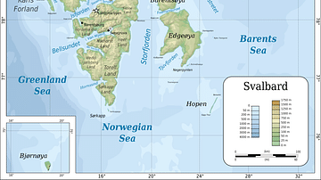
Topographic map of Svalbard

Map of the Four Voyages of Christopher Columbus, 1492 - 1504

Map of the Voyages of Christopher Columbus 1492-1504

Map of European Exploration of Africa, c. 1434-1877 - From Coastal Voyages to Continental Expeditions

Map of Spanish Conquest & Exploration in North America
Cite This Work
APA Style
Barentsz., W. (2022, January 08). 1598 Map of the Three Arctic Voyages (1594–1596) by Willem Barentsz. World History Encyclopedia. https://www.worldhistory.org/image/15091/1598-map-of-the-three-arctic-voyages-1594-1596-by/
Chicago Style
Barentsz., Willem. "1598 Map of the Three Arctic Voyages (1594–1596) by Willem Barentsz." World History Encyclopedia, January 08, 2022. https://www.worldhistory.org/image/15091/1598-map-of-the-three-arctic-voyages-1594-1596-by/.
MLA Style
Barentsz., Willem. "1598 Map of the Three Arctic Voyages (1594–1596) by Willem Barentsz." World History Encyclopedia, 08 Jan 2022, https://www.worldhistory.org/image/15091/1598-map-of-the-three-arctic-voyages-1594-1596-by/.