


Map of the Persian Achaemenid Empire at its greatest extent under the reigns of Darius the Great and Xerxes. Inspired by Historical Atlas of Georges Duby (p.11, map D), this map was made by Fabienkhan the 24th of August 2006, using Inkscape and GIMP. Arad translated the map to help.
Related Images

Map of Sogdiana, ca. 300 BCE

Map of the Achaemenid Persian Empire c. 500 BCE

Map of the Achaemenid Persian Empire - Animation
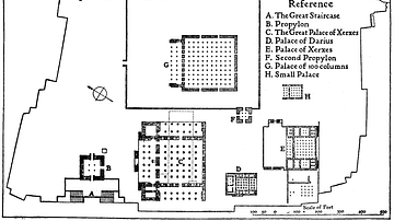
Map of Persepolis
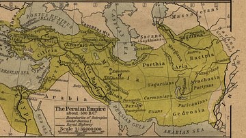
The Persian Empire

Map of the Tang Dynasty of China, c. 669 CE
References
World History Encyclopedia is an Amazon Associate and earns a commission on qualifying book purchases.Cite This Work
APA Style
Fabienkhan. (2012, April 26). Achaemenid Empire Map. World History Encyclopedia. https://www.worldhistory.org/image/148/achaemenid-empire-map/
Chicago Style
Fabienkhan. "Achaemenid Empire Map." World History Encyclopedia, April 26, 2012. https://www.worldhistory.org/image/148/achaemenid-empire-map/.
MLA Style
Fabienkhan. "Achaemenid Empire Map." World History Encyclopedia, 26 Apr 2012, https://www.worldhistory.org/image/148/achaemenid-empire-map/.