


This map illustrates the dynamic trade networks of the ancient Mediterranean between the 7th and 4th centuries BCE, highlighting the spheres of influence of the Phoenicians and Greeks as they established settlements, trading posts, and seafaring routes across the region. It reveals a vibrant commercial landscape shaped by maritime connectivity and cultural exchange, spanning from Iberia to the Levant and deep into the Black Sea and North Africa.
The Phoenicians, master shipbuilders and traders from the Levant, dominated the western and southern Mediterranean coasts, founding colonies like Carthage and Cádiz. Meanwhile, Greek settlers expanded eastward and westward, establishing cities from Asia Minor to Sicily. Trade routes facilitated the flow of goods such as wine, olive oil, metals, and luxury items, while also spreading artistic styles, writing systems, and technologies. The map also reflects the broader geopolitical backdrop, including the presence of the Persian Empire and overland links like the Silk Road and Incense Route, underscoring the region's pivotal role in ancient global commerce.
About the Author

Related Images

Magna Graecia

Phoenician Trade Network

Greek and Phoenician Colonization

Map of the Roman Trade Network (1st - 3rd centuries CE)

Map of the Hanseatic League Trade Network, c. 1400
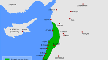
Map of Phoenicia
Cite This Work
APA Style
Netchev, S. (2021, August 16). Map of the Trade Routes in the Ancient Mediterranean. World History Encyclopedia. https://www.worldhistory.org/image/14421/map-of-the-trade-routes-in-the-ancient-mediterrane/
Chicago Style
Netchev, Simeon. "Map of the Trade Routes in the Ancient Mediterranean." World History Encyclopedia, August 16, 2021. https://www.worldhistory.org/image/14421/map-of-the-trade-routes-in-the-ancient-mediterrane/.
MLA Style
Netchev, Simeon. "Map of the Trade Routes in the Ancient Mediterranean." World History Encyclopedia, 16 Aug 2021, https://www.worldhistory.org/image/14421/map-of-the-trade-routes-in-the-ancient-mediterrane/.