


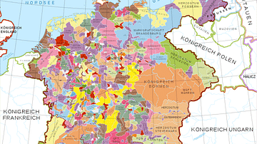
Map of the Holy Roman Empire depicting its boundaries following the Peace of Westphalia in 1648 CE.
Related Images

Map of Europe at the Peace of Westphalia, 1648 - From the Thirty Years’ War to a New European Order

Map of the Holy Roman Empire under Otto the Great c. 972

Map of the Holy Roman Empire, 972-1032 CE
Holy Roman Empire in the 13th century CE

Map of the Provinces of the Roman Empire under Augustus

Map of the Roman Empire under Theodosius the Great, c.395 - The Last Unified Roman Empire
Cite This Work
APA Style
Astrokey44. (2021, March 22). Map of the Holy Roman Empire, 1648 CE. World History Encyclopedia. https://www.worldhistory.org/image/13699/map-of-the-holy-roman-empire-1648-ce/
Chicago Style
Astrokey44. "Map of the Holy Roman Empire, 1648 CE." World History Encyclopedia, March 22, 2021. https://www.worldhistory.org/image/13699/map-of-the-holy-roman-empire-1648-ce/.
MLA Style
Astrokey44. "Map of the Holy Roman Empire, 1648 CE." World History Encyclopedia, 22 Mar 2021, https://www.worldhistory.org/image/13699/map-of-the-holy-roman-empire-1648-ce/.