


The map shows the position of Triballian territory on Balkan Peninsula between the 4th century BCE and Celtic invasion of 279 BCE, when the Triballi tribe was pushed further east. The Triballi were a Thracian tribe inhabiting the area of modern day South and Eastern Serbia, Western Bulgaria and Northern part of Republic of North Macedonia. They were a warlike people that frequently fought against their neighbors. The map of the Balkans was created by d-maps.com, and modified by Andrej Zivojin to show the location of the Triballi tribe.
Related Images
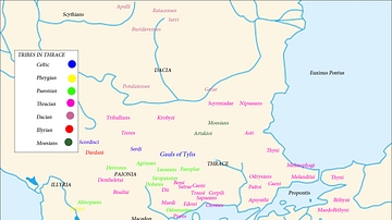
Map of the Tribes in Thrace

Roman Rule in Thrace, c. 200 CE

Map of the Ming Dynasty Territory

Map of Nok Culture Territory

Spartan Territory
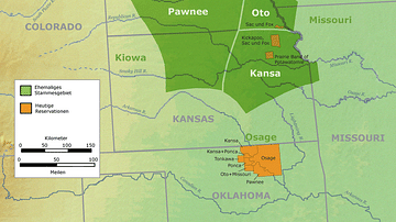
Tribal Territory of the Pawnee
References
World History Encyclopedia is an Amazon Associate and earns a commission on qualifying book purchases.Cite This Work
APA Style
d-maps.com. (2019, December 05). Map of Triballian Territory. World History Encyclopedia. https://www.worldhistory.org/image/11565/map-of-triballian-territory/
Chicago Style
d-maps.com. "Map of Triballian Territory." World History Encyclopedia, December 05, 2019. https://www.worldhistory.org/image/11565/map-of-triballian-territory/.
MLA Style
d-maps.com. "Map of Triballian Territory." World History Encyclopedia, 05 Dec 2019, https://www.worldhistory.org/image/11565/map-of-triballian-territory/.