
Server Costs Fundraiser 2026


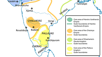
This is a political map of India showing the important kingdoms that existed around 590 CE after the disintegration of the Gupta Empire (3rd century CE to 6th century CE). The main players appear to be the Chalukyas in the south and the west, the Pallavas in the extreme south and the Later Guptas in the east. This is also the period in which dynasties like the Pushyabhutis and Maukharis are becoming prominent in the north.
Related Images

Coin of the Gauda King Shashanka
Ancient India in 625 CE

Robert Clive & The East India Company Rule in India, c. 1765

The Rashtrakuta, Gurjara-Pratihara and Pala Empires, Ancient India

The Four Castes of Ancient India - The Varna System

Gurjara-Pratihara Empire, Ancient India
Cite This Work
APA Style
Woudloper. (2019, March 29). Ancient India in 590 CE. World History Encyclopedia. https://www.worldhistory.org/image/10331/ancient-india-in-590-ce/
Chicago Style
Woudloper. "Ancient India in 590 CE." World History Encyclopedia, March 29, 2019. https://www.worldhistory.org/image/10331/ancient-india-in-590-ce/.
MLA Style
Woudloper. "Ancient India in 590 CE." World History Encyclopedia, 29 Mar 2019, https://www.worldhistory.org/image/10331/ancient-india-in-590-ce/.