
Search
Remove Ads
Advertisement
Search Results
Image
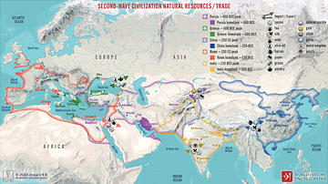
Second-Wave Civilization Natural Resources and Trade
A map illustrating the rise and spread of the Second Wave Civilizations between c. 500 BCE and 200 CE (including the Persians, the Greeks, the Romans, the Chinese, and India) with the flows of trade in major goods and resources.

Definition
Kingdom of Benin
The Kingdom of Benin, located in the southern forests of West Africa (modern Nigeria) and formed by the Edo people, flourished from the 13th to 19th century CE. The capital, also called Benin, was the hub of a trade network exclusively controlled...

Definition
Wolof Empire
The Wolof (aka Jolof or Djolof) Empire was a state on the coast of West Africa, located between the Senegal and Gambia rivers, which thrived from the mid-14th to mid-16th century CE. The empire prospered on trade thanks to the two rivers...

Definition
Portuguese Macao
Macao (Macau) is located on a peninsula in the estuary of the Pearl River delta in southeast China and it was a Portuguese colonial settlement from c. 1557 until 1999. Macao was a major trade hub of the Portuguese Empire and with its unique...

Definition
Estado da India
The Estado da India (1505-1961) was the name the Portuguese gave to that part of their empire which stretched from India to East Asia. However, in its widest sense, the name includes all Portuguese colonies east of the Cape of Good Hope and...
Definition
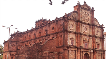
Portuguese Goa
Goa, located on the west coast of India, was a Portuguese colony from 1510 to 1961. The small coastal area was conquered by Afonso de Albuquerque (c. 1453-1515) and became an important trade hub for the Eastern spice trade. Goa was the capital...

Definition
Dutch East India Company
The Dutch East India Company (VOC) was formed in 1602 by the Staten-Generaal (States General) of the then Republic of the Seven United Netherlands. The company was granted a 21-year charter with rights to trade exclusively in Asia and to...

Definition
John Hawkins
Sir John Hawkins (1532-1595 CE) was an Elizabethan mariner, merchant and naval administrator who has the inglorious (if not wholly accurate) record of being England's first slave trader. In the 1560s CE Hawkins trafficked slaves from West...

Video
Yaxchilan, Chiapas, The Mayan Route
www.themayanroute.con

Definition
Silk Road
The Silk Road was a network of ancient trade routes, formally established during the Han Dynasty of China in 130 BCE, which linked the regions of the ancient world in commerce between 130 BCE-1453 CE. The Silk Road was not a single route...