
Search
Remove Ads
Advertisement
Search Results

Collection
Trade in the Middle Ages
Peoples, cities and states have traded since antiquity but in the medieval period, things escalated so that goods travelled ever greater distances by land, river and sea. Great cities arose thanks to commerce and international trade such...
Image
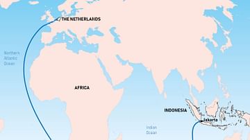
The Brouwer Route
The Dutch East India Company's favoured route from Europe to southeast Asia was known as the Brouwer Route. It was discovered by Dutch explorer Hendrik Brouwer (c. 1581-1643) in 1611 and halved the sailing time from the Netherlands to the...

Lesson Pack
Geography, Economy, & Trade in Ancient Egypt
We have prepared three lesson plans including classroom activities, assignments, homework, and keys as well as: - Multiple choice quiz questions in an excel format. - Glossary of keywords and concepts in an excel format. - Open questions...

Image
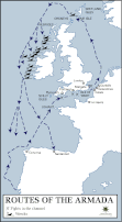
Map of the Route of The Spanish Armada, Jul-Sep 1588
A map illustrating the route and failing fortunes of the Spanish Armada (from Spanish - Grande y Felicísima Armada, “Great and Most Fortunate Fleet”) in 1588. A crucial part of a planned invasion of England by King Philip II of Spain, the...
Image
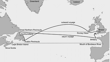
John Cabot's Route to Newfoundland
The Italian explorer John Cabot (aka Giovanni Caboto, c. 1450 - c. 1498 CE) sailed from England to eastern Canada in 1497 CE. His exact route and points of exploration are unclear and the map is therefore only an approximate guide.
Image
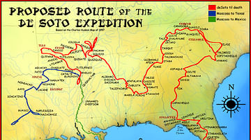
Route of the de Soto Expedition
Map showing the route of Hernando de Soto's expedition. Based on the 1997 Charles Hudson map.

Image
Map of the Bismarck's Route
A map showing the route taken by the German battleship Bismarck prior to its sinking in May 1941.

Image
Map of Hannibal's Route into Italy
Hannibal's route into Italy in the Second Punic War.
Image
Route Map of the Spanish Armada
A map showing the route of the Spanish Armada from May to October 1588 CE. The Armada was sent by Philip II of Spain (r. 1556-1598 CE) to invade the kingdom of Elizabeth I of England (r. 1558-1603 CE) but was defeated by the Royal Navy and...

Image
The Route of the St Jean Baptiste and the Endeavour around the North Cape of New Zealand
The route of the St Jean Baptiste and Captain James Cook's Endeavour around the North Cape of New Zealand in December 1769.