
Search
Remove Ads
Advertisement
Search Results

Definition
Portuguese Angola
Portuguese Angola in southwest Africa was the first European colony on that continent. While settlement from 1571 proved problematic in the interior, the Portuguese did obtain a large number of slaves which they shipped to their Atlantic...

Image
Map of Roman & Parthian Trade Routes
This map shows the Roman-Parthian trade route system, circa between the 1st and the 3rd centuries CE. During this period, the Roman Empire and the Parthian Empire were the two superpowers of the region and the Roman-Parthian trade system...

Image
Hellenistic Trade Routes, 300 BCE
Alexander the Great died in Babylon on the 13th of June, 323 BCE. His Macedonian-Greek empire broke apart, but Alexander’s heritage was felt throughout the ancient Mediterranean world for centuries. Three Hellenic empires emerged from the...

Definition
Henry Hudson
Henry Hudson (c. 1570-1611) was an English navigator and maritime explorer. He is known for his four voyages between 1607 and 1610 in search of a northwest passage via the Arctic Ocean to the Far East. The lure of a northwest passage became...

Collection
Trade & Commerce in Ancient Greece
The ancient Mediterranean was a busy place with trading ships sailing in all directions to connect cities and cultures. The Greeks were so keen on the rewards of trade and commerce that they colonized large parts of the coastal Mediterranean...

Image
Map of the East India Company Trade, c.1800
The English East India Company (EIC) was established by Royal Charter on 31 December 1600 under Queen Elizabeth I (reign 1558–1603), granting it a monopoly on English trade east of the Cape of Good Hope. Initially conceived as a commercial...
Image
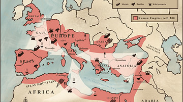
Trade in the Roman Empire Map (c. 200 CE)
This map shows the major sources of trade goods in the Roman Empire, circa 200 CE. The map shows the sources of the following trade goods: grain, olive oil, slaves, wine, metals, textiles and wild animals.

Definition
Portuguese Nagasaki
Nagasaki, on the northwest coast of Japan’s Kyushu Island, was an important Portuguese trading base from c. 1571 to 1639, and the most eastern outpost of the Portuguese empire. The Portuguese presence transformed Nagasaki from a small fishing...

Image
Phoenician Trade Network
Map of Phoenicia and its trade routes.
Image
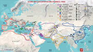
Second-Wave Civilization Natural Resources and Trade
A map illustrating the rise and spread of the Second Wave Civilizations between c. 500 BCE and 200 CE (including the Persians, the Greeks, the Romans, the Chinese, and India) with the flows of trade in major goods and resources.