
Search
Remove Ads
Advertisement
Search Results
Image
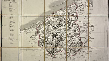
Map of the Lys Department
This antique map of Belgium represents the Lys department under the First French Empire. It was created in the early 19th century by French geographer Pierre-Gilles Chanlaire and is part of the Atlas National de France. The map illustrates...
Image
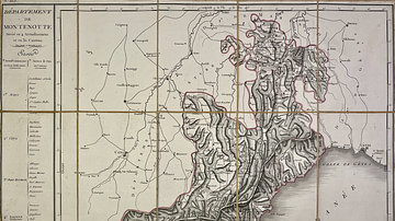
Map of the Montenotte Department
This antique map of Italy depicts the Montenotte department under the First French Empire. It was created in the early 19th century by French geographer Pierre-Gilles Chanlaire and is included in the Atlas National de France. The map reflects...
Image
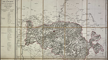
Map of the Ourthe Department
This antique map of Belgium represents the Ourthe department under the First French Empire. It was produced in the early 19th century by French geographer Pierre-Gilles Chanlaire and is part of the Atlas National de France. The map reflects...
Image
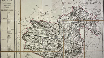
Map of the Stura Department
This antique map of Italy depicts the First French Empire’s department of Stura. Created in the early 19th century by French geographer Pierre-Gilles Chanlaire, it is part of the Atlas National de France. The map reflects the administrative...

Image
Prince Peter Bagration
Prince Peter Bagration (1765-1812), a Russian general of Georgian origin who served during the Napoleonic Wars (1803-1815). He commanded one of Russia's main armies during Napoleon's invasion of Russia and was mortally wounded at the Battle...
Image
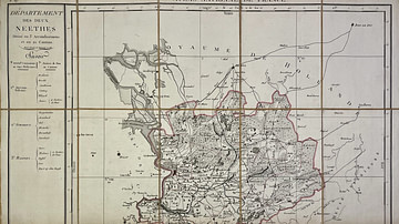
Map of the Deux-Nèthes Department
This antique map of Belgium depicts the Deux-Nèthes department under the First French Empire. It was created in the early 19th century by French geographer Pierre-Gilles Chanlaire and is part of the Atlas National de France. The map reflects...
Image
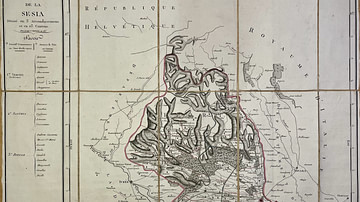
Map of the Sesia Department
This antique map of Italy shows the department of Sesia under the First French Empire. It was created in the early 19th century by French geographer Pierre-Gilles Chanlaire and is part of the Atlas National de France. The map reflects the...
Image
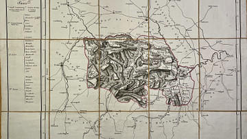
Map of the Marengo Department
This antique map of Italy shows the Marengo department under the First French Empire. It was produced in the early 19th century by French geographer Pierre-Gilles Chanlaire and is part of the Atlas National de France. The map reflects the...

Image
Map of the Rhin-et-Moselle Department
This antique map of Germany represents the department of Rhin-et-Moselle under the First French Empire. It was produced in the early 19th century by French geographer Pierre-Gilles Chanlaire and is included in the Atlas National de France...

Image
Map of the Forêts Department
This antique map of Belgium depicts the Forêts department under the First French Empire. It was created in the early 19th century by French geographer Pierre-Gilles Chanlaire and is part of the Atlas National de France. The map illustrates...