
Search
Remove Ads
Advertisement
Search Results
Image
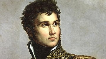
Jean Lannes
Jean Lannes (1769-1809), 1st Duke of Montebello, a marshal of the French Empire during the Napoleonic Wars. Oil on canvas portrait painting by Julie Volpelière after an original by Antoine-François Gérard, 1834. In the Musée de l'Armée...
Image
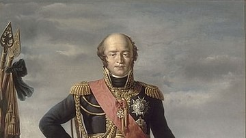
Louis-Nicolas Davout
Louis-Nicolas Davout (1770-1823), Duke of Auerstedt and a marshal of the French Empire during the Napoleonic Wars (1803-1815). Nicknamed the "Iron Marshal" for the strict discipline he imposed on his Corps, Davout never lost a battle and...

Image
British Army Infantry Square
An 1875 oil on canvas painting by Elizabeth Thompson titled The 28th Regiment at Quatre Bras (a battle during the Napoleonic Wars). The British infantry is shown employing the classic defensive strategy of a square, where each rank fires...

Image
Map of the Roer Department
This antique map of Germany depicts the department of the Roer during the First French Empire. It was created in the early 19th century by French geographer Pierre-Gilles Chanlaire and is part of the Atlas National de France. The map documents...
Image
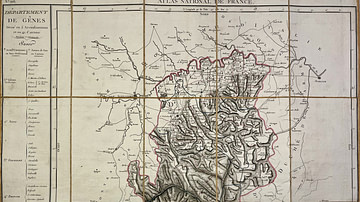
Map of the Genoa Department
This antique map of Italy represents the Genoa department under the First French Empire. It was produced in the early 19th century by French geographer Pierre-Gilles Chanlaire and is part of the Atlas National de France. The map reflects...
Image
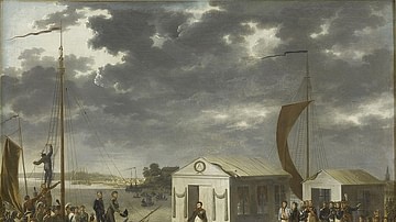
Meeting of Napoleon and Alexander I at Tilsit, 25 June 1807
Emperor Napoleon I of France (r. 1804-1814; 1815) meets with Tsar Alexander I of Russia (1801-1825) on a specially built raft in the middle of the Niemen River to discuss peace. It is one of the most iconic episodes of the Napoleonic Era...
Image
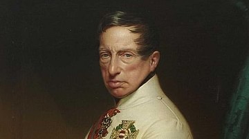
Archduke Charles of Austria
Archduke Charles of Austria, Duke of Teschen (1771-1847), brother of Austrian Emperor Francis I, and one of Austria's most capable generals during the French Revolutionary Wars (1792-1802) and the Napoleonic Wars (1803-1815). He is best known...
Image
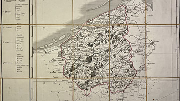
Map of the Lys Department
This antique map of Belgium represents the Lys department under the First French Empire. It was created in the early 19th century by French geographer Pierre-Gilles Chanlaire and is part of the Atlas National de France. The map illustrates...
Image
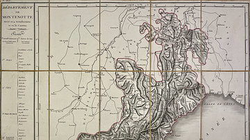
Map of the Montenotte Department
This antique map of Italy depicts the Montenotte department under the First French Empire. It was created in the early 19th century by French geographer Pierre-Gilles Chanlaire and is included in the Atlas National de France. The map reflects...

Image
Map of the Sambre-et-Meuse Department
This antique map of Belgium shows the department of Sambre-et-Meuse under the First French Empire. It was created in the early 19th century by French geographer Pierre-Gilles Chanlaire and forms part of the Atlas National de France. The map...