
Search
Remove Ads
Advertisement
Search Results

Definition
Portuguese Nagasaki
Nagasaki, on the northwest coast of Japan’s Kyushu Island, was an important Portuguese trading base from c. 1571 to 1639, and the most eastern outpost of the Portuguese empire. The Portuguese presence transformed Nagasaki from a small fishing...

Image
Trade in the Roman Empire Map (c. 200 CE)
This map shows the major sources of trade goods in the Roman Empire, circa 200 CE. The map shows the sources of the following trade goods: grain, olive oil, slaves, wine, metals, textiles and wild animals.

Image
Map of Roman & Parthian Trade Routes
This map shows the Roman-Parthian trade route system, circa between the 1st and the 3rd centuries CE. During this period, the Roman Empire and the Parthian Empire were the two superpowers of the region and the Roman-Parthian trade system...

Image
Map of the Roman Trade Network (1st - 3rd centuries CE)
This map illustrates the main maritime and overland trade arteries that bound the Roman Empire together between the first and third centuries CE. From grain fleets in the Mediterranean to camel caravans across the desert and river barges...

Image
Late Medieval Land & Maritime Trade Routes
A map showing the late medieval trade routes by land and sea across Europe and Western Asia.

Image
Phoenician Trade Network
Map of Phoenicia and its trade routes.
Image
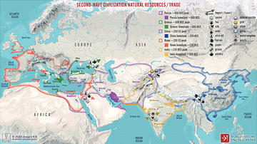
Second-Wave Civilization Natural Resources and Trade
A map illustrating the rise and spread of the Second Wave Civilizations between c. 500 BCE and 200 CE (including the Persians, the Greeks, the Romans, the Chinese, and India) with the flows of trade in major goods and resources.

Image
Map of the Trade Networks in the Middle Ages, c. 1200
By the early 13th century (c. 1200 CE), long-distance trade networks across Eurasia and the Mediterranean had regained a level of interconnectivity not seen since late antiquity. After the political fragmentation that followed the fall of...

Image
Slave Trade
Execrable Human Traffick, or The Affectionate Slaves, oil on canvas by George Morland, c. 1788. Depicted here is a scene of a man being abducted by slavers on the coast of Africa as his family watches. From the 16th to the 19th century...

Definition
Silk Road
The Silk Road was a network of ancient trade routes, formally established during the Han Dynasty of China in 130 BCE, which linked the regions of the ancient world in commerce between 130 BCE-1453 CE. The Silk Road was not a single route...