
Search
Search Results

Image
Slave Trade
Execrable Human Traffick, or The Affectionate Slaves, oil on canvas by George Morland, c. 1788. Depicted here is a scene of a man being abducted by slavers on the coast of Africa as his family watches. From the 16th to the 19th century...
Image
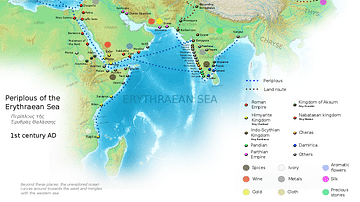
Ancient Indian Maritime Trade Routes
This map is derived from the book Periplus of the Erythraean Sea. It depicts trade routes in the ancient world, ports in the Chera territory and other parts of India and the trade routes connecting them to other parts of the world along with...

Definition
Portuguese Macao
Macao (Macau) is located on a peninsula in the estuary of the Pearl River delta in southeast China and it was a Portuguese colonial settlement from c. 1557 until 1999. Macao was a major trade hub of the Portuguese Empire and with its unique...

Image
Map of Medieval Japanese Trade & Wako Pirates
Map depicting Medieval Japan and its trade relations with its neighbours, China and Korea. The map shows the major trade goods exchanged between Japan, China, and Korea. Black lines show the approximate routes taken by the Wako Pirates. Each...

Image
Transatlantic Triangular Trade Map
Map showing the flow of goods and enslaved people across the Atlantic between Europe, Africa and America in the transatlantic triangular trade which the European colonial powers operated from the 16th to the 19th centuries CE. This triangular...

Image
Map of Trade Networks of the Late Bronze Age Mediterranean - Empires, Merchants, and Maritime Routes of the Ancient World
The Late Bronze Age eastern Mediterranean (c. 1500–1200 BCE) was marked by an unprecedented level of diplomatic and commercial interdependence among regional powers. Great kingdoms, including New Kingdom Egypt (c. 1550–1077 BCE), the Hittite...

Image
Trans-Saharan Trade Routes
A map indicating the major trans-Saharan trade routes across West Africa c. 1100-1500 CE. The darker yellow areas indicate gold fields.

Image
Trade Union Scroll for the Amalgamated Society of Engineers
A trade union scroll for the Amalgamated Society of Engineers, created in January 1851. The scroll shows illustrations of important engineers and inventions during the Industrial Revolution. (Science Museum, London)

Quiz
Roman Trade & Economy
Roman economy trade Amphora, Amphorae Argentarii Commerce Free Market Economy Garum Mensarii Mint Nummularii Pax Romana Princeps State-Controlled Economy Veto

Video
Ancient and Medieval Gold Trade in West Africa
Did you know that the Ghana king would automatically keep any gold nugget extracted that weighed between 25 grams and half a kilo? This video is all about the lucrative gold trade of ancient and medieval West Africa. West Africa was...