
Search
Remove Ads
Advertisement
Search Results

Image
Map of Yuan Dynasty China
A map indicating the territory of the Mongol Yuan dynasty of China (1271-1368 CE).

Image
Ming Dynasty Blue-and-White Porcelain
A selection of Ming Dynasty (1368-1644 CE) blue-and-white porcelain. From Chenghua reign, 1465-1487 CE. (British Museum, London)

Image
Northern Song Dynasty Map
A map indicating the territory of the Northern Song Dynasty of China, 960-1125 CE.

Image
Map of the Ming Dynasty Territory
A map indicating the territory controlled by the Ming Dynasty (1368 to 1644 CE) in the late 16th century CE.

Image
Celadon Fish-Dragon Ewer, Goryeo Dynasty
A celadon fish-dragon ewer. 12th century CE, Goryeo Dynasty, Korea. (National Museum of Korea, Soul, South Korea)

Image
Qin Dynasty Crossbow
A Qin dynasty crossbow (221-207 BCE). From Beiguan, Xian, China.
Image
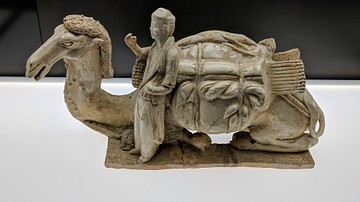
Camel with Guide, Tang Dynasty
Lying camel with guide, China, Tang Dynasty, early 7th century CE. Made from stone with a white glaze. Exhibited at Museum Rietberg, Zurich, Switzerland.

Image
Flag of the Abbasid Dynasty
This flag was used by the Abbasid Dynasty in addition to the simple black standard of their family.

Image
Zhou Dynasty Jade Dragon
A Chinese jade dragon. Zhou Dynasty, 5th-4th century BCE. Height: 9 cm.
The British Museum, London.

Image
Hannibal and the Barcid Dynasty - Carthage’s Iberian Gamble
The Barcid Dynasty rose to prominence during the crisis years of the First and Second Punic Wars, shaping Carthaginian military strategy in the western Mediterranean (c. 275–203 BCE). In the aftermath of the First Punic War (264–241 BCE...