Search
Search Results

Image Gallery
Faces of Roman Emperors: Nerva to the Severan Dynasty
A series of facial reconstructions of Roman emperors from the Nerva-Antonine Dynasty (96 CE-192 CE), the Year of the Five Emperors (193 CE) and the Severan Dynasty (193-235 CE). These photorealistic representations are only best guesses at...

Definition
Middle Kingdom of Egypt
The Middle Kingdom (2040-1782 BCE) is considered ancient Egypt's Classical Age during which it produced some of its greatest works of art and literature. Scholars remain divided on which dynasties constitute the Middle Kingdom as some argue...

Definition
Old Kingdom of Egypt
The Old Kingdom of Egypt (c. 2613-2181 BCE) is also known as the 'Age of the Pyramids' or 'Age of the Pyramid Builders' as it includes the great 4th Dynasty when King Sneferu perfected the art of pyramid building and the pyramids of Giza...

Image
Shang Dynasty of China, c. 1100 BCE
This map illustrates the rise and expansion of the Shang dynasty, which emerged around 1600 BCE after the fall of the Xia dynasty. Centered on the North China Plain, the Shang established a hereditary monarchy with a centralized government...

Image
Map of the Tang Dynasty of China, c. 669 CE
The Tang Dynasty (618–907 CE) represents one of the high points of imperial Chinese history, reaching its widest territorial extent during the reign of Emperor Gaozong (reign 649–683 CE). By the late 7th century, around 669 CE, the empire...

Image
Map of the Ming Dynasty of China, 1368-1644
The Ming Dynasty (1368-1644) marked the restoration of native Han Chinese rule after the collapse of the Mongol-led Yuan Dynasty (1271-1368). Founded by the Hongwu Emperor (Zhu Yuanzhang, reign 1368-1398), the Ming state reasserted centralized...

Image
Family Tree of the Ptolemaic Dynasty of Egypt (305-30 BCE)
This infographic illustrates the royal lineage of the Ptolemaic Dynasty, which ruled Egypt during the Hellenistic period (305–30 BCE). Founded by Ptolemy I Soter, a companion of Alexander the Great, the dynasty is notable for elevating royal...

Image
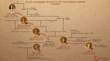
Julio-Claudian Dynasty of the Roman Empire
A depiction of the evolution of the first imperial dynasty of ancient Rome, the Julio-Claudians that began with Augustus (Julius Caesar's adopted son) and included the reigns of Tiberius, Caligula, Claudius, and Nero. During their time, Rome...

Image
Tang Dynasty Provinces c. 742 CE
The provinces of the Tang Dynasty c. 742 CE. The Tang Dynasty (618-907 CE) is regularly cited as the greatest imperial dynasty in ancient Chinese history. It was a golden age of reform and cultural advancement, which lay the groundwork for...

Image
The Barcid Dynasty of Carthage
This infographic illustrates the rise and influence of the Barcid Dynasty, a powerful Carthaginian family that shaped Carthage’s military and political strategy during the third century BCE. Active from circa 260 to 200 BCE, the Barcids played...