
Search
Remove Ads
Advertisement
Search Results

Image
Map of Tthe Ancient Near East c. 1700 BCE - The Old Assyrian Empire - between cities and kingdoms
Around c. 1700 BCE, the Ancient Near East was a politically fragmented but highly interconnected region, shaped by shifting alliances, commercial networks, and emerging territorial states. This period corresponds to the Old Assyrian era and...

Image
The Ancient Near East, c. 1300 BCE - On the Eve of Collapse: Power and Politics in the Late Bronze Age
This map illustrates the shifting political landscape of the Ancient Near East in the 13th century BCE, a period marked by the rise of imperial powers and the decline of older kingdoms. The expansion of the Hittite and Assyrian empires redrew...

Article
Battle of Fleurus
The Battle of Fleurus (26 June 1794) was the climax of the Flanders Campaign of 1792-95 and was one of the most decisive battles in the War of the First Coalition (1792-1797). A French victory, Fleurus ensured French ascendency for the rest...

Definition
Estado da India
The Estado da India (1505-1961) was the name the Portuguese gave to that part of their empire which stretched from India to East Asia. However, in its widest sense, the name includes all Portuguese colonies east of the Cape of Good Hope and...

Image
Robert Clive & The East India Company Rule in India, c. 1765
A map illustrating the transformation of the East India Company from a hopeful merchant venture in 1600 with isolated trade outposts governed by isolated and mostly independent town councils into a major ruler of large territories in India...

Image
Map of the ancient Near East during the Amarna Period
Map of the ancient Near East during the Amarna Period, showing the great powers of the period: Egypt (green), Hatti (yellow), the Kassite kingdom of Babylon (purple), Assyria (grey), and Mittani (red). Lighter areas show direct control, darker...
Image
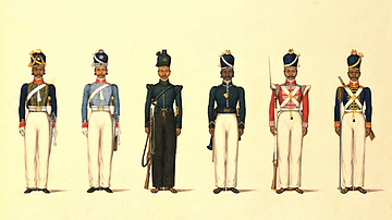
East India Company Madras Uniforms
A c. 1830 illustration by Yellapah of Vellore showing six Sepoy uniforms of the East India Company Madras army. From left to right: - Madras Horse Artillery - Madras Light Cavalry - Madras Rifle Corps - Madras Pioneers - Madras...

Image
East Asia in the year 1 CE
This map shows the boundaries of all major civilizations in East Asia at the beginning of the first millennium, with italics indicating nomadic bands and other tribal societies.

Image
Maji-Maji Rebellion, German East Africa
An early-20th-century painting by Wilhelm Kuhnert depicting German-led African Askari troops at the Battle of Mahenge during the Maji-Maji Rebellion (1905-7) against colonial rule in German East Africa.
Image
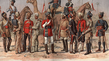
East India Company Madras Army
A 19th-century illustration showing officers and sepoys (Indian recruits) of the East India Company's Madras army.