
Search
Did you mean: Delos?
Remove Ads
Advertisement
Search Results

Image
Encyclopedie Frontispiece
The frontispiece of the Encyclopedia, a massive multi-volume work first published in 1751 and chiefly edited by Diderot (1713-1784). The figure in the centre is Truth whose light radiates forth and disperses the clouds of ignorance. Engraved...

Image
Diderot by Louis-Michel van Loo
A 1767 oil on canvas portrait by Louis-Michel van Loo of the French author and philosopher Diderot (1713-1784). (Louvre Museum, Paris)
Image
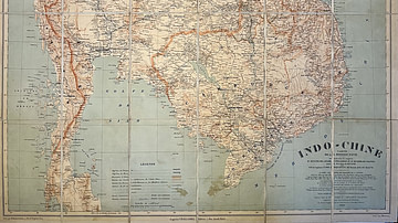
Map of Indochina by the Pavie Mission
This antique map of Indochina, dated 1909, was produced under the direction of Auguste Pavie and based on surveys carried out by members of the Pavie Mission between 1880 and 1895. It was created under the auspices of the French Ministry...

Image
Map of the Battle of Rivoli, 14 January 1797 - French and Austrian Positions in Detail
This detailed map of the Battle of Rivoli, won by the French Army on 14 January 1797, was dedicated to His Majesty Emperor Alexander by General Jomini. Engraved by Blondeau and scripted by Sauvé, the map precisely illustrates the positions...

Image
Map of the Indian Rebellion of 1857 - Published by J. Barthelemier, Paris
This antique map of India illustrates the Indian Rebellion of 1857, also known as the Sepoy Mutiny. It was published by J. Barthelemier, successor to Ch. Picquet. The map provides a geographical overview of the uprising, reflecting key locations...
Image
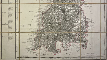
Map of the Mont-Tonnerre Department
This antique map of Germany represents the Mont-Tonnerre department under the First French Empire. It was produced in the early 19th century by French geographer Pierre-Gilles Chanlaire and is part of the Atlas National de France. The map...

Image
Topographic and Military Map of Stockach and Engen - French and Austrian Positions, 1799–1800
This topographic and military map was created to support the understanding of the Battle of Stockach, won by Archduke Charles in 1799, as well as the Battles of Engen and Moskirch, won by the Army of the Rhine in 1800. It presents in detail...
Image
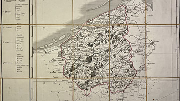
Map of the Lys Department
This antique map of Belgium represents the Lys department under the First French Empire. It was created in the early 19th century by French geographer Pierre-Gilles Chanlaire and is part of the Atlas National de France. The map illustrates...

Image
Military Map of the French Border, Maubeuge to Douai - Campaigns of 1793–1794 With Army Positions
This military map covers the French border region from Maubeuge to Douai and was designed to support the understanding of the campaigns conducted between 1793 and 1794. It details the positions of French and Austrian forces during this phase...
Image
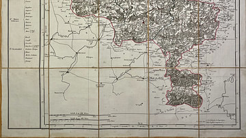
Map of the Jemappes Department
This antique map of Belgium depicts the Jemappes department under the First French Empire. It was created in the early 19th century by French geographer Pierre-Gilles Chanlaire and is included in the Atlas National de France. The map reflects...