
Server Costs Fundraiser 2026


This detailed map of the Battle of Rivoli, won by the French Army on 14 January 1797, was dedicated to His Majesty Emperor Alexander by General Jomini. Engraved by Blondeau and scripted by Sauvé, the map precisely illustrates the positions of French and Austrian forces during the engagement. It serves as a valuable cartographic record of one of the key victories of the Italian campaign. Source: Votre Carte Ancienne – antique maps of Italy.
About the Author

Related Images

Napoleon: Map of the Battle of Rivoli, 14-15 Jan 1797

Map of the Italian Empire in 1942 - The Spatial and Political Dimensions of Italian Imperialism

Map of WWII North Africa Campaign, 1940-1943
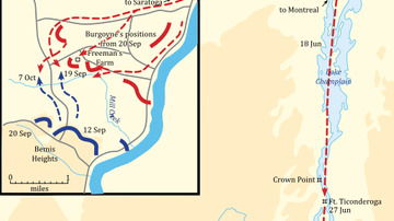
Saratoga Campaign Map

Territorial Expansion of Libya under Italian Colonial rule
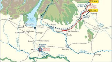
Initial Phase of the Arcole Campaign
Cite This Work
APA Style
Denis, L. (2025, May 23). Map of the Battle of Rivoli, 14 January 1797: French and Austrian Positions in Detail. World History Encyclopedia. https://www.worldhistory.org/image/20470/map-of-the-battle-of-rivoli-14-january-1797/
Chicago Style
Denis, Léopold. "Map of the Battle of Rivoli, 14 January 1797: French and Austrian Positions in Detail." World History Encyclopedia, May 23, 2025. https://www.worldhistory.org/image/20470/map-of-the-battle-of-rivoli-14-january-1797/.
MLA Style
Denis, Léopold. "Map of the Battle of Rivoli, 14 January 1797: French and Austrian Positions in Detail." World History Encyclopedia, 23 May 2025, https://www.worldhistory.org/image/20470/map-of-the-battle-of-rivoli-14-january-1797/.