
Search
Remove Ads
Advertisement
Search Results

Image
Prominent Cities of Europe from Antiquity to the Present
A map of Europe displaying important cities that shaped its history, from antiquity to the present. Cities on the map represent key centers throughout history. Each city represents a distinct period from Athens, Rome, and Constantinople (now...

Image
Map of Elizabethan Trade with Europe, c. 1600 - Trade and Diplomacy in the Tudor World
During the reign of Queen Elizabeth I (reign 1558–1603), England underwent a decisive commercial transformation, expanding its trade networks across northern and southern Europe at a moment of shifting geopolitical and economic balance. The...

Image
Map of the Holocaust in Europe during World War II
During World War II (1939-1945), Nazi Germany under Adolf Hitler (rule 1933-1945) carried out the Holocaust, a systematic, state-directed genocide that resulted in the murder of approximately six million Jews, alongside millions of other...

Image
Totalitarian Regimes in Europe in 1939
This map illustrates the geopolitical situation in Europe in the lead-up to the Second World War (1939-45) as authoritarianism and totalitarianism were on the rise across the continent, fueled by political instability, economic crises, and...

Image
An Illustrated Map of Medieval and Early Modern Europe (From the Novel "The Jericho River")
An illustrated map of medieval and early modern Europe. From the novel The Jericho River by David Tollen.

Image
The Formidable Women Who Shaped Medieval Europe
Cover of The Formidable Women Who Shaped Medieval Europe: Power and Patronage at the Burgundian Court by Susan Abernethy. This is a collection of 31 women who were related by blood, marriage, and politics to the Valois Dukes of Burgundy...

Image
Oldest Mural in Europe
This photo shows a reconstruction of the "Cult Wall" of Ludwigshafen, the oldest mural in Europe. The original painting was created around 3860 BCE, depicting hunting trophies of aurochs and bison, fine textiles, as well as a human torso...
Image
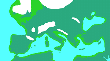
Europe During the Last Glacial Maximum
Europe during the most recent glacial, in which the ice sheets reached peak growth between c. 26.500 to c. 19,000 years ago. This is known as the Last Glacial Maximum. Sea levels were lower than today.

Image
Map of the World War I in Europe, May 1917
A map illustrating the situation in Europe around May 1917, during the First World War (World War I or The Great War), as the conflict had already raged on for nearly three years. The United States had recently entered the war, beginning...

Image
Map of Europe at the Peace of Westphalia, 1648 - From the Thirty Years’ War to a New European Order
The Peace of Westphalia (1648), concluded through treaties signed at Osnabrück and Münster (May-October 1648), marked the end of two major conflicts: the Thirty Years’ War and the Eighty Years’ War. What began as a religious and dynastic...