
Search
Remove Ads
Advertisement
Search Results

Definition
Medes
The Medes or Medians were a group of Indo-Iranian-speaking people from central Asia who migrated westwards and entered northern Iran around the end of the 2nd millennium BCE. They settled in the highlands of Zagros (Zagreus in Greek) and...

Definition
Mesopotamian Government - Helping and Serving the Gods
Ancient Mesopotamian government was based on the understanding that human beings were created to help and serve the gods. The high priest, king, assembly of elders, governors, and any other officials were recognized as stewards chosen by...
Image
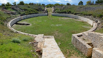
Roman military amphitheatre
The military amphitheatre of Burnum Legionary Camp in Dalmatia (modern-day Croatia). It was completed in 76-77 CE under Vespasian. The legionary camp was erected at the turn of the new era at a strategically important position from which...

Definition
Mesopotamian Warfare - Early Development of Armed Conflict
Ancient Mesopotamian warfare progressed from companies of a city's militia in Sumer to the professional standing armies of Akkad, Babylon, Assyria, and Persia, and from conflicts over land or water rights to wars of conquest and political...
Image
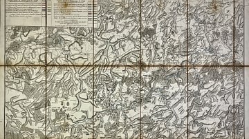
Military Map of the Course of the Sambre - Campaigns and Army Positions, 1792 to 1794
This military map of the Sambre River in Northern France and Wallonia, Belgium illustrates key strategic movements and battlefield positions from 1792 to 1794, with particular emphasis on the campaigns of 1793 and 1794. It offers a detailed...
Article
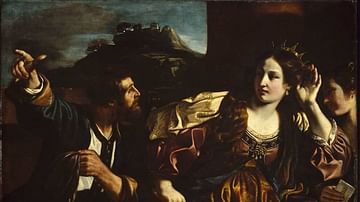
Sammu-Ramat and Semiramis: The Inspiration and the Myth
Sammu-Ramat (r. 811-806 BCE) was the queen regent of the Assyrian Empire who held the throne for her young son Adad Nirari III (r. 811-783 BCE) until he reached maturity. She is also known as Shammuramat, Sammuramat, and, most notably, as...
Image
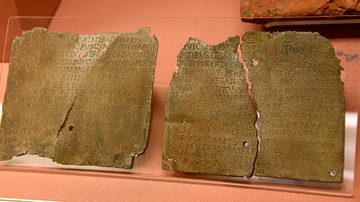
Bronze Roman Military Diploma
This official military discharge comprising 2 inscribed bronze plates was a copy of a master held in Rome. It was issued by the Emperor Trajan to Reburrus, a Spanish junior officer (decurion) in the 1st Pannonian cavalry regoiment. The certificate...

Image
The Military Crusader Orders, 11-13 Century
An infographic showing the Military Crusader Orders which emerged as unique institutions blending monastic devotion with martial duty. Founded in the wake of the First Crusade (1096–1099), their primary purpose was to protect pilgrims and...

Definition
Mesopotamian Literature - The Earliest Works of the Imagination
Ancient Mesopotamian literature developed circa 2600 BCE after scribes, who had formerly been record-keepers, began composing original works in the region of Sumer. The Sumerians invented writing circa 3600/3500 BCE, refined the script circa...

Image
Statue of a Military Commander from Hatra
This is a limestone statue of a high-ranking military commander of the army. He wears his military uniform and holds in both hands what appears to be a statue of a deity. His name is unidentified. It was found in the 4th temple at Hatra...