
Server Costs Fundraiser 2026


This military map of the Sambre River in Northern France and Wallonia, Belgium illustrates key strategic movements and battlefield positions from 1792 to 1794, with particular emphasis on the campaigns of 1793 and 1794. It offers a detailed understanding of the operations conducted in this region during the War of the First Coalition (1792-1797). The troop placements and maneuvers depicted highlight the intensity of the military efforts along this vital river corridor.
About the Author

Related Images

Map of the Sambre-et-Meuse Department

Map of the First Anglo-Boer War, 1880–1881 - Resistance, Imperial Overreach & the Limits of British Power

Map of Niger River
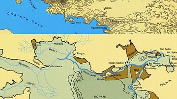
Maps of Boeotia, Lake Copais, Gla & Orchomenos
Map of New France, 1612 CE
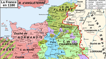
Map of 12th-Century France
Cite This Work
APA Style
Denis, L. (2025, May 27). Military Map of the Course of the Sambre: Campaigns and Army Positions, 1792 to 1794. World History Encyclopedia. https://www.worldhistory.org/image/20468/military-map-of-the-course-of-the-sambre/
Chicago Style
Denis, Léopold. "Military Map of the Course of the Sambre: Campaigns and Army Positions, 1792 to 1794." World History Encyclopedia, May 27, 2025. https://www.worldhistory.org/image/20468/military-map-of-the-course-of-the-sambre/.
MLA Style
Denis, Léopold. "Military Map of the Course of the Sambre: Campaigns and Army Positions, 1792 to 1794." World History Encyclopedia, 27 May 2025, https://www.worldhistory.org/image/20468/military-map-of-the-course-of-the-sambre/.