
Search
Remove Ads
Advertisement
Search Results
Image
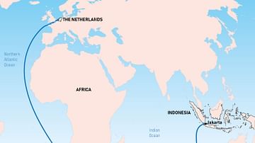
The Brouwer Route
The Dutch East India Company's favoured route from Europe to southeast Asia was known as the Brouwer Route. It was discovered by Dutch explorer Hendrik Brouwer (c. 1581-1643) in 1611 and halved the sailing time from the Netherlands to the...

Definition
Portuguese Cochin
Cochin, located on the southwest coast of India, was a Portuguese colony from 1503 to 1663. Known to the Portuguese as Cochim, it was one of several important cities on India’s Malabar Coast and a great trade centre for spices like pepper...

Lesson Pack
Mesopotamia: Geography, Economy & Trade
This lesson pack on geography, economy and trade in ancient Mesopotamia includes the following content: Lesson Plans - Mesopotamia's Geography - Resources & Trade Additional Materials - Open Questions / Essay Questions - Quiz Questions...

Image
Map of the Route of The Spanish Armada, Jul-Sep 1588
A map illustrating the route and failing fortunes of the Spanish Armada (from Spanish - Grande y Felicísima Armada, “Great and Most Fortunate Fleet”) in 1588. A crucial part of a planned invasion of England by King Philip II of Spain, the...

Definition
Ferdinand Magellan
Ferdinand Magellan, or Fernão de Magalhães (c. 1480-1521), was a Portuguese mariner whose expedition was the first to circumnavigate the globe in 1519-22 in the service of Spain. Magellan was killed on the voyage in what is today the Philippines...

Article
The Dutch Discovery of Australia
17th-century Dutch East India Company (Vereenigde Oostindische Compagnie or VOC) navigators were the first Europeans to set foot on Australian soil. Although there is a strong theory that the Portuguese explorer, Cristóvão de Mendonça (1475-1532...
Article
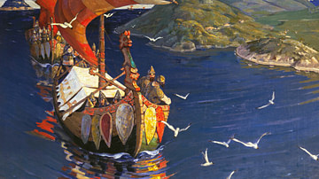
Trade & Warfare in the Kievan Rus
Scandinavians from the island of Gotland began to spread throughout the Baltic region along the Russian rivers in the 700s. While the Vikings of Norway and Denmark from the 8th to 11th centuries are widely recognized as fearsome raiders and...
Image
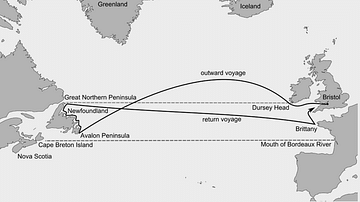
John Cabot's Route to Newfoundland
The Italian explorer John Cabot (aka Giovanni Caboto, c. 1450 - c. 1498 CE) sailed from England to eastern Canada in 1497 CE. His exact route and points of exploration are unclear and the map is therefore only an approximate guide.

Worksheet/Activity
Trade in the Roman Empire - Web Quest & Map Skills
This activity has been designed to fit a 20-30-minute slot for your class and is suitable for both online and classroom teaching. Students have to do a web quest in order to complete a map. It is part of our Roman Economy and Trade pack...

Image
Map of the Bismarck's Route
A map showing the route taken by the German battleship Bismarck prior to its sinking in May 1941.