
Search
Remove Ads
Advertisement
Search Results

Image
Hittite Foundation Figurine
This bronze figurine was shaped like Mesopotamian foundation figurines. The figure wears the tall headdress of a Hittite god. From South-Eastern Anatolia, in modern-day Turkey. Old Hittite period, c. 1600 BCE. (The British Museum, London).
Image
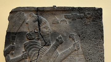
Hittite King Barrekub
In this basalt wall relief, King Barrekub prays in front of divine symbols. The Hittite hieroglyphic inscriptions talk about the construction of a new palace. Sam'al (modern-day Sinjerli, Gaziantep, Turkey). Late Hittite period, 8th century...
Definition
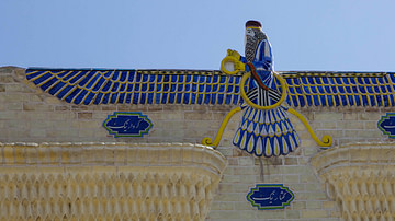
Zarathustra
Zarathustra (also given as Zoroaster, Zartosht, Zarathustra Spitama, l. c. 1500-1000 BCE) was the Persian priest-turned-prophet who founded the religion of Zoroastrianism (also given as Mazdayasna “devotion to Mazda”), the first monotheistic...

Definition
Lycia
Lycia is a mountainous region in south-west Anatolia (also known as Asia Minor, modern-day Turkey). The earliest references to Lycia can be traced through Hittite texts to sometime before 1200 BCE, where it is known as the Lukka Lands. The...

Definition
Ankhsenamun
Ankhsenamun (born c. 1350 BCE and known as Ankhesenpaaten in youth) was the daughter of Akhenaten and Nefertiti of the 18th Dynasty of Egypt. She was married to her father and may have borne him one daughter, Ankhesenpaaten Tasherit ('Ankhesenpaaten...

Image
Winged Hittite Griffin-Demons
Relief orthostat (stone slab at the base of a wall) depicting two winged griffin demons, depicted as bird-headed with a human body. From Carchemish, Turkey. Dated to the Late Hittite period, 9-7th century BCE. Museum of Anatolian Civilization...
Image
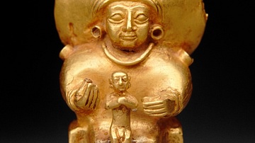
Seated Hittite Goddess with Child
Seated Hittite Goddess with Child, c. 14th-13th century BCE, from Central Anatolia, Metropolitan Museum of Art, New York.
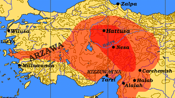
Image
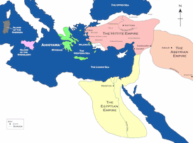
Map of the Hittite Empire and Surrounding States
A map of the Hittite Empire and surrounding states, including the Assyrian Empire, the Egyptian Empire, and Ahhiyawa.
This map is an extract from the book Empires of Bronze by Gordon Doherty, republished with permission.
Image
Hittite Empire c. 1300 BCE
The Hittite Empire at its maximum extension c. 1300 BCE (indicated in red. The Eyptian area of influence is indicated in green).

Image
Map of the Hittite Empire
A map showing the Hittite Empire in c. 1350-1300 BCE (dark green line) and at its maximum extent (light green area).