
Search
Remove Ads
Advertisement
Search Results

Image
Eastern Han Pig Sculpture
A dolomite sculpture of a recumbent pig. Eastern Han Dynasty, 25-220 CE. Height: 3 cm. Length: 10.6 cm. (Metropolitan Museum of Art, New York)

Image
Map of Europe Before the Fall of Constantinople, c. 1450
Around 1450 CE, Europe and the Middle East were defined by fragmentation, declining medieval powers, and the rise of new regional states. The Byzantine Empire had contracted to Constantinople and a few outposts, while the Ottoman Empire under...

Image
Map of the Migration Period in Europe in the 4th-5th Century
The Migration Period in Europe (c. 4th–6th centuries CE) marks a prolonged era of movement, conflict, and political transformation rather than a single moment of collapse. Following the death of Emperor Theodosius I (reign 379–395 CE) and...

Article
The Ancient Celtic Pantheon
The ancient Celtic pantheon consisted of over 400 gods and goddesses who represented everything from rivers to warfare. With perhaps the exception of Lugh, the Celtic gods were not universally worshipped across Iron Age Europe but were very...
Image
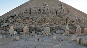
Eastern Terrace of Mount Nemrut
Overview of the thrones and the heads of the gods on the eastern terrace of Mount Nemrut. From left to right: King Antiochus I, Commagene-Fortuna, Zeus-Oromasdes, Apollo-Mithras and Hercules. Mount Nemrut (Turkish: Nemrut Dağı) is one of...

Definition
Nazi-Soviet Pact
The Nazi-Soviet Pact, also called the Molotov-Ribbentrop Pact after the respective foreign ministers of the USSR and Germany, was a non-aggression agreement signed in August 1939. The pact allowed the leader of Nazi Germany Adolf Hitler (1889-1945...

Image
Map of Europe after the Congress of Vienna, 1815
The Congress of Vienna (September 1814–June 1815) marked a decisive attempt by Europe’s great powers to reconstruct political order after more than two decades of revolutionary and Napoleonic warfare (1792–1815). Led principally by Austria...
Image
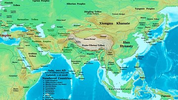
Map of the Eastern Hemisphere (1 CE)
Map showing the political division in the Eastern hemisphere in 1 CE. The Han dynasty was almost at its peak in terms of geographical expansion.
Image
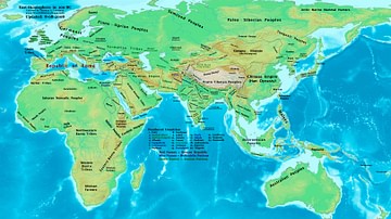
The Eastern Hemisphere, 100 BC
A map showing the major empires, kingdoms, tribes, and ethnic groups of the Eastern Hemisphere in 100 BC.

Image
Map of Eastern Mediterranean in 1450 CE
Geopolitical climate in the Eastern Mediterranean before the conquest of Constantinople in 1453 CE.