
Search
Remove Ads
Advertisement
Search Results
Image
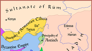
Map of The Latin East, 1190 CE
A map of the Middle East showing the Crusader-held Latin East states at the time of the Third Crusade (1189-1192 CE).

Image
Map of Mesopotamia and the Ancient Near East, c. 1300 BCE
Map of Mesopotamia and the Ancient Near East c. 1300 BCE, showing the period of Great Powers, with the six large kingdoms and empires (the Hittites, the Mycenaean Civilization, Assyria, Babylonia, Elam and the New Kingdom of Egypt) co-existing...

Image
Map of the Trade Links between Rome & the East
The network popularly known as the Silk Road refers not to a single route but to a shifting constellation of overland and maritime pathways that connected East and West across more than a millennium. Long before the term was coined in the...
Image
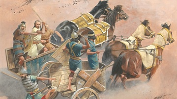
Chariot Warfare in the Ancient Near East
An illustration of what chariot warfare looked like in the ancient Near East. Illustration by by Zvonimir Grbasic.

Image
East Pagoda, Yakushiji
The East Pagoda of Yakushiji temple, Nara, Japan. The three-story pagoda is original and dates to the 8th century CE and rises to a height of 33 metres (108 ft).

Image
Weavers, Scribes, and Kings: A New History of the Ancient Near East by Amanda H. Podany
Weavers, Scribes, and Kings: A New History of the Ancient Near East by Amanda H. Podany

Image
Parthenon, East Facade
East facade of the Parthenon, Athens, 5th century BCE.

Image
The Near East in 1135 CE
This map of the Near East in 1135 CE shows four Crusader States (marked with red crosses) in relation to other powerful kingdoms in the period between the first and second crusades.

Image
East Pediment of the Parthenon
The left section of the east pediment of the Parthenon. On the far left Helios and his chariot rise from the base of the pediment, next is Dionysos reclining, then the figures are female deities, possibly Demeter, Kore and Artemis. (British...

Image
Athena (after the East pediment of the Parthenon)
A Pentelic marble statue of Athena considered to be similar to that originally on the East pediment of the Parthenon. The statue was dedicated to Artemis, mid-3rd century CE. (National Archaeological Museum, Athens)