
Search
Remove Ads
Advertisement
Search Results

Article
Britain and the Suez Canal - 75 Years of Colonialism & Crisis
The Suez Canal in Egypt, which links the Mediterranean to the Red Sea, was taken over by the British in 1882 and was only reluctantly released 75 years later. The seizure in the 19th century caused an international furore every bit as damaging...

Article
Fall of the East India Company
The British East India Company (1600-1874) was the largest and most successful private enterprise ever created. All-powerful wherever it colonised, the EIC's use of its own private army and increasing territorial control, particularly in...

Article
The Colonial Bungalow - Combatting Climate & Creating Separation
With its thick walls, high ceilings, large rooms, and wide verandahs, the colonial bungalow was constructed to meet the challenges of hot climates. Designed to keep cool air in, hot air out, and provide plenty of airy shade, the bungalow...

Article
The Crusades: Consequences & Effects
The crusades of the 11th to 15th century CE have become one of the defining events of the Middle Ages in both Europe and the Middle East. The campaigns brought significant consequences wherever they occurred but also pushed changes within...

Article
Fatima Al-Fihri and Al-Qarawiyyin University
Fatima Al-Fihri (c. 800-880) was a Muslim woman, scholar and philanthropist who is credited with founding the world’s oldest, continuously running university during the 9th century: the University of Al-Qarawiyyin, located in Fez in Morocco...

Article
The Seven Voyages of Zheng He
Admiral Zheng He (aka Cheng Ho, c. 1371-1433 CE) was a Chinese Muslim eunuch explorer who was sent by the Ming dynasty emperor Yongle (r. 1403-1424 CE) on seven diplomatic missions to increase trade and secure tribute from foreign powers...
Article
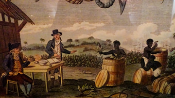
Tobacco & Colonial American Economy
The most important cash crop in Colonial America was tobacco, first cultivated by the English at their Jamestown Colony of Virginia in 1610 CE by the merchant John Rolfe (l. 1585-1622 CE). Tobacco grew in the wild prior to this time and was...

Article
4 Women of the French Revolution
The French Revolution (1789-1799) sought to dismantle the oppressive society of the old regime and build a new world based on the principles of "Liberty, Equality, Fraternity". This push for societal change led to a burgeoning feminist movement...

Article
Native American Enslavement in Colonial America
Slavery was practiced by the Native Americans before any Europeans arrived in the region. People of one tribe could be taken by another for a variety of reasons but, whatever the reason, it was understood that the enslaved had done something...
Article
Macedonian Colonization Under Philip II
Philip II of Macedon (359-336 BCE) envisaged a broad Macedonian kingdom and his colonial expansion resulted in the forging of an empire that his son Alexander the Great (r. 336-323 BCE) would use as a springboard for even greater things...