
Search
Remove Ads
Advertisement
Search Results

Image
The South China Sea in the 18th Century
A late-18th century map of the South China Sea. Drawn by Rigobert Bonne and G. Raynal

Image
Rhine Frontier of the Roman Empire, 4th century CE.
A map showing the Rhine frontier of the Roman Empire in the 4th century CE.

Image
Detail of a 6th-century Elephant Mosaic
Detail of a 6th-century mosaic floor that used to decorate the pavement of the peristyle court of the Palatium Magnum, the Great Palace of Constantinople. The Great Palace Mosaic Museum houses mosaics from the Byzantine period, unearthed...

Image
16th Century Morion Helmet
A typical steel morion helmet, a type worn across Europe in the 16th century and worn by conquistadors in the New World. Italian, c. 1570. (Metropolitan Museum of Art, New York)

Image
China Warlords, 2nd-3rd century CE.
A map showing the territories of the main Chinese warlords at the fall of the Han dynasty in the early 3rd century CE.

Image
East Roman Empire, 6th century CE
East Roman Empire, 6th century CE, showing the territories of the Avars, Goths, Franks, Lombards, Saxons, Thuringians, Slavs.

Image
5th Century BCE Demareteion Coin
An illustration of the so-called Demaretéion is a silver coin of ancient Syracuse (weighing around 43 g) rather rare and worth 10 drachmas. It is also known as a pentekontalitron because it was equivalent to 50 litrae (the litra was a silver...

Image
Costa Rica, 16th century CE
Map of Costa Rica in the 16th century CE.
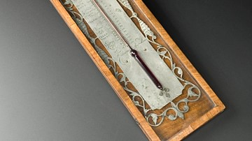
Image
18th-Century Alcohol Thermometer
An 18th-century alcohol thermometer. Made in the Netherlands between 1720 and 1750. (Science Museum, London)

Image
Monte Cassino in the 15th Century
Illustration of Monte Cassino in the 15th-century Nuremberg Chronicle. Published in Nuremberg, Germany, 1493.