
Server Costs Fundraiser 2026

Infographic illustrating the rise and fall of the Roman Empire and the land they controlled. Originally created as part of an installation for the Vindolanda Museum at Hadrian's Wall on the English / Scottish border. Exhibition design by Studio MB, all design and animation by ISO. http://isodesign.co.uk
Related Content
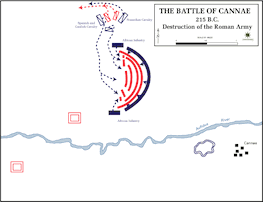
Battle of Cannae - Destruction of the Roman Army

Map of the Provinces of the Roman Empire under Augustus

Map of the Roman Empire under Septimius Severus, 193-211 CE - Reshaping an Empire: Power, Ambition, and the Birth of a Military Dynasty

Map of Odysseus’ 10-year Journey Home

Map of the Roman Empire under Theodosius the Great, c.395 - The Last Unified Roman Empire

Map of the Fall of the Western Roman Empire, c. 480 CE
Cite This Work
APA Style
DESIGN, I. (2017, February 07). Roman Army Museum – Empire Map. World History Encyclopedia. https://www.worldhistory.org/video/1088/roman-army-museum---empire-map/
Chicago Style
DESIGN, ISO. "Roman Army Museum – Empire Map." World History Encyclopedia, February 07, 2017. https://www.worldhistory.org/video/1088/roman-army-museum---empire-map/.
MLA Style
DESIGN, ISO. "Roman Army Museum – Empire Map." World History Encyclopedia, 07 Feb 2017, https://www.worldhistory.org/video/1088/roman-army-museum---empire-map/.