
Search Images
Browse Content (p. 1885)

Image
Map of the Greco-Bactrian Kingdom
Approximate maximum extent of the Greco-Bactrian kingdom circa 180 BCE, including the regions of Tapuria and Traxiane to the West, Sogdiana and Ferghana to the north, Bactria and Arachosia to the south.

Image
Satyrs Making Wine
Satyrs making wine, dionysian bas-relief from altar of unknown date, National Archaeological Museum of Athens.

Image
Map of Hannibal's Route into Italy
Hannibal's route into Italy in the Second Punic War.
Image
Map of the Battle of Trebia
Map of the Battle of Trebia (218 BC), illustrating Hannibal's strategy.
Image
The Battle of Lake Trasimene
As Hannibal passed Lake Trasimene, he came to a place very suitable for an ambush, and hearing that Flaminius had broken camp and was pursuing him, made preparations for the impending battle. To the north was a series of heavily forested...

Image
Map of Troy
Plan of the archeological site of Troy/Hisarlik. Legend: 1: Gate 2: City Wall 3: Megarons 4: FN Gate 5: FO Gate 6: FM Gate and Ramp 7: FJ Gate 8: City Wall 9: Megarons 10: City Wall 11: VI. S Gate 12: VI. H Tower 13: VI. R...
Image
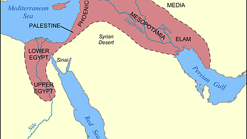
Map of the Fertile Crescent
This map shows the location and extent of the Fertile Crescent, a region in the Middle East incorporating ancient Egypt; the Levant; and Mesopotamia.

Image
Threshing of Grain in Egypt
From the grave of Menna, the agricultural scribe of the Pharaoh. Scene: Threshing of grain. c. 1422-1411 BCE

Image
Map of the ancient Near East during the Amarna Period
Map of the ancient Near East during the Amarna Period, showing the great powers of the period: Egypt (green), Hatti (yellow), the Kassite kingdom of Babylon (purple), Assyria (grey), and Mittani (red). Lighter areas show direct control, darker...

Image
Carthage during the Punic Wars
Map of the Carthaginian Empire and its losses during the Punic Wars.