
Search
Remove Ads
Advertisement
Summary 
Loading AI-generated summary based on World History Encyclopedia articles ...
Search Results
Image
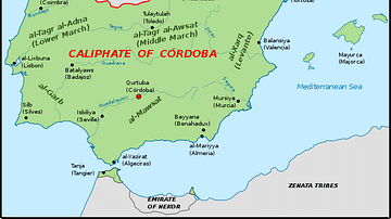
The Iberian Peninsula, c. 1000 CE
A map of the Iberian peninsula c. 1000 CE showing the divide between the Muslim Caliphate of Cordoba in the south and the Christian kingdoms in the north.

Image
The Taifa Kingdoms of the Iberian Peninsula, 1031-1086
This map shows the fractured landscape of al-Andalus following the collapse of the Umayyad Caliphate of Córdoba in 1031. Dozens of independent Muslim-ruled states, called taifas (from the Arabic for "party" or "faction"), rose from the ruins—engaged...
Interview
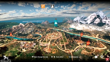
Interview: Numantia - Recreating the Ancient Iberian World
RECOTechnology is a small game-developer studio based in Madrid, Spain. Their latest video game - Numantia - allows players to explore the conflicts between the ancient Iberians and ancient Romans. James Blake Wiener of Ancient History Encyclopedia...

Article
The Iberian Conquest of the Americas
European explorers began to probe the Western Hemisphere in the early 1500s, and they found to their utter amazement not only a huge landmass but also a world filled with several diverse and populous indigenous cultures. Among their most...
Image
Nemuro Peninsula Chashi
The Nemuro Peninsula Chashi Sites are a series of hilltop fortifications built by the Ainu. The earthen palisades were built between the 16th and 18th Century, and are associated with the 1789 Menashi–Kunashir rebellion. Hokkaidō, Japan.

Image
View from the Dingle Peninsula, County Kerry, Ireland
View from a stretch of the Dingle Peninsula, County Kerry, Ireland.
Image
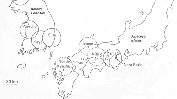
The Korean Peninsula and the Japanese Archipelago, 3rd-6th century CE
Map of Pen/Insular states and potential centres in the 3rd–6th centuries CE.
Image
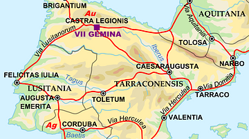
Map of the Iberian Penninsula in 125 AD
A map showing Iberian peninsula in 125 AD including important roads, locations of legions and gold (Au) and silver (Ag) mines.
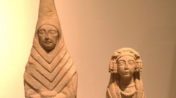
Image
Iberian Female Offerants
These offering bearers made from limestone are the most common type of representation found at the ancient Iberian Shrine of Cerro de los Santos (Montealegre de Castillo, Albacete) in Spain. These specimens date from the 3rd-2nd century BCE...
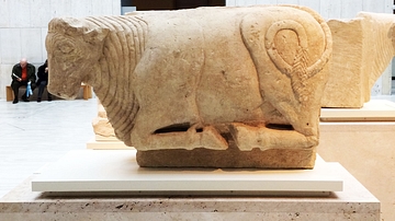
Image
Iberian Bull Statue
This limestone statue of a bull comes from Osuna (Seville), Spain. It dates from the late 5th century CE. It was originally abutted to a funerary monument. Bulls were protectors of tombs, symbols of masculinity, and they were also associated...