


Map showing the Median, Lydian, Chaldean, and Egyptian empires around 600 BC.
Related Images

Image
Ancient Mesopotamia from Cities to Empires
The long-term development of Mesopotamia traces one of the earliest...
Image
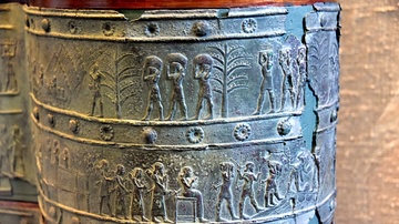
The Tribute of Chaldea
The upper register shows Chaldeans from the city of Bit-Dakuri...
Image
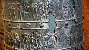
The Tribute of Chaldea
The upper register shows Chaldeans from the city of Bit-Dakuri...

Image
The Earliest Coins from Lydia
These are some of the earliest coins in the World. Made from electrum...

Image
Map of Lydia
Map of Lydia in the middle of the 6th century BCE. The red line...

Image
Lydia Electrum Stater
Electrum coin depicting an uncertain king of Lydia, early 6th century...
Cite This Work
APA Style
Collection, P. M. (2012, April 26). The Oriental Empires. World History Encyclopedia. https://www.worldhistory.org/image/76/the-oriental-empires/
Chicago Style
Collection, PCL Map. "The Oriental Empires." World History Encyclopedia, April 26, 2012. https://www.worldhistory.org/image/76/the-oriental-empires/.
MLA Style
Collection, PCL Map. "The Oriental Empires." World History Encyclopedia, 26 Apr 2012, https://www.worldhistory.org/image/76/the-oriental-empires/.