


Related Images
Image
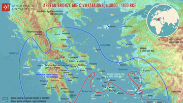
Map of the Aegean Bronze Age Civilizations, c. 3000-1100 BCE - From Minoan Maritime Exchange to Mycenaean Dominance
The Aegean world of the Bronze Age (c. 3000–1100 BCE) was shaped...
Image
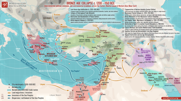
Map of the Late Bronze Age Collapse c. 1200 - 1150 BCE
The Late Bronze Age Collapse (c. 1200–1150 BCE) marks a period...

Image
Map of Trade Networks of the Late Bronze Age Mediterranean - Empires, Merchants, and Maritime Routes of the Ancient World
The Late Bronze Age eastern Mediterranean (c. 1500–1200 BCE) was...

Image
Some Active Trade Routes in the Bronze Age Mediterranean
A map detailing some of the active maritime trade routes in the...

Image
Bronze Age Mediterranean Invasions & Migrations
A map of the Late Bronze Age Mediterranean indicating the various...

Image
Map of India in the Vedic Age, 1500 BCE-500 BCE - Indo-Aryan Cultures in Northern India
The Vedic Age (c. 1500-500 BCE) marks a formative period in the...
References
- Akrotiri on Thera, accessed 1 Dec 2016.
- Akrotiri on Thera, accessed 1 Dec 2016.
- Santorini ancient Greece : excavations map, accessed 1 Dec 2016.
- http://appearfr.english-heritage.org.uk/photos/448.jpg, accessed 1 Dec 2016.
- http://www.therafoundation.org/akrotiri/map, accessed 1 Dec 2016.
Cite This Work
APA Style
Dörrbecker, M. (2012, July 07). Map of Bronze Age Akrotiri. World History Encyclopedia. https://www.worldhistory.org/image/754/map-of-bronze-age-akrotiri/
Chicago Style
Dörrbecker, Maximilian. "Map of Bronze Age Akrotiri." World History Encyclopedia, July 07, 2012. https://www.worldhistory.org/image/754/map-of-bronze-age-akrotiri/.
MLA Style
Dörrbecker, Maximilian. "Map of Bronze Age Akrotiri." World History Encyclopedia, 07 Jul 2012, https://www.worldhistory.org/image/754/map-of-bronze-age-akrotiri/.