
Server Costs Fundraiser 2026


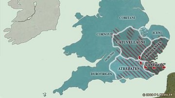
Rome maintained trading and political links of a sort with the Britons, and were able to observe the slow coalescence of the south-east towards the creation of a unified kingdom. The Catuvellauni, who had already proved themselves to be national leaders in times of external threat, were starting to make their presence felt far and wide. By about AD 1 they had already placed a Catuvellauni prince, Cunobelinus, as ruler of the Trinovantes, and in circa AD 10 he became king of the Catuvellauni themselves, uniting the two kingdoms. In around AD 25 the Catuvellauni also seem to have gained control of the Cantiaci, and Cunobelinus' brother seized the throne of the Atrebates, fighting a war to dislodge the ruling house from the southern half (the territory of the Belgae) and gaining it all by AD 43. The tribes further north and west had still not been identified by the Romans in the form that they are shown here, but whatever names they were using, they certainly existed, and were becoming more sophisticated as Roman imports made their way inland from the kingdoms on the coast.
Related Images

Map of the British Isles in AD 43
Map of the British Isles in 54 BC
Map of Roman Britain, 150 AD
British Isles at the Beginning of the 10th Century

Map of the Roman Rule in Britain c. 43 - 410 CE - Four Centuries of Empire at the Edge of the World

Map of the Battle of Britain, 1940
Cite This Work
APA Style
Kessler, P. L. (2012, July 06). Map of the British Isles in AD 10. World History Encyclopedia. https://www.worldhistory.org/image/740/map-of-the-british-isles-in-ad-10/
Chicago Style
Kessler, P L. "Map of the British Isles in AD 10." World History Encyclopedia, July 06, 2012. https://www.worldhistory.org/image/740/map-of-the-british-isles-in-ad-10/.
MLA Style
Kessler, P L. "Map of the British Isles in AD 10." World History Encyclopedia, 06 Jul 2012, https://www.worldhistory.org/image/740/map-of-the-british-isles-in-ad-10/.