


Related Images

Image
Robert Clive & The East India Company Rule in India, c. 1765
A map illustrating the transformation of the East India Company...

Image
Map of Indo-Euopean Migrations
A map indicating the possible routes of Indo-European migrations.

Image
Map of India in the Vedic Age, 1500 BCE-500 BCE - Indo-Aryan Cultures in Northern India
The Vedic Age (c. 1500-500 BCE) marks a formative period in the...

Image
Map of the Hellenistic Kingdoms after Alexander, c.301 BCE
The Hellenistic Successor Kingdoms (the Diadochi, from the Greek...

Image
Map of the Wars of the Three Kingdoms - Britain in Civil War (1642–1651)
The conflicts commonly known as the English Civil Wars form part...
Image
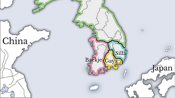
Three Kingdoms of Korea Map
A map showing the three kingdoms (Goguryeo, Silla, and Baekje...
Cite This Work
APA Style
Imaging, W. (2012, April 26). Map of the Indo-Saka Kingdoms. World History Encyclopedia. https://www.worldhistory.org/image/311/map-of-the-indo-saka-kingdoms/
Chicago Style
Imaging, World. "Map of the Indo-Saka Kingdoms." World History Encyclopedia, April 26, 2012. https://www.worldhistory.org/image/311/map-of-the-indo-saka-kingdoms/.
MLA Style
Imaging, World. "Map of the Indo-Saka Kingdoms." World History Encyclopedia, 26 Apr 2012, https://www.worldhistory.org/image/311/map-of-the-indo-saka-kingdoms/.