
Server Costs Fundraiser 2026


This antique map of Turkey depicts the surroundings of Constantinople (modern-day Istanbul) and was published by the British War Office in 1909. It offers a detailed view of the region at the beginning of the 20th century, reflecting both strategic and geographic considerations of the time. Source: Votre Carte Ancienne – antique maps of Turkey.
About the Author

Related Images

Map of Byzantine Constantinople

Map of Europe Before the Fall of Constantinople, c. 1450

Map of the Latin Empire: A Crusader State in Constantinople - Imperium Romaniae and the Fragmentation of Byzantium
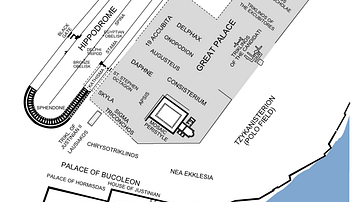
Plan of the Hippodrome of Constantinople

Map of Odysseus’ 10-year Journey Home

Map of the Silk Road During the Late 8th Century
Cite This Work
APA Style
Denis, L. (2025, May 27). Map of the Surroundings of Constantinople, 1909: Published by the War Office, United Kingdom. World History Encyclopedia. https://www.worldhistory.org/image/20488/map-of-the-surroundings-of-constantinople-1909/
Chicago Style
Denis, Léopold. "Map of the Surroundings of Constantinople, 1909: Published by the War Office, United Kingdom." World History Encyclopedia, May 27, 2025. https://www.worldhistory.org/image/20488/map-of-the-surroundings-of-constantinople-1909/.
MLA Style
Denis, Léopold. "Map of the Surroundings of Constantinople, 1909: Published by the War Office, United Kingdom." World History Encyclopedia, 27 May 2025, https://www.worldhistory.org/image/20488/map-of-the-surroundings-of-constantinople-1909/.