
Illustration


This map traces the course of the Rhine River from Strasbourg to Mainz and was designed to support the understanding of military operations conducted between 1792 and 1796. It presents in detail the positions of both Austrian and French forces, offering a precise geographic reference for the study of campaigns in this strategic corridor. Source: Votre Carte Ancienne – antique maps of Germany.
About the Author

Related Images
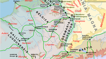
Map of the Rhine frontier of the Roman empire, 70AD
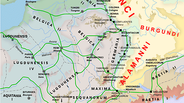
Rhine Frontier of the Roman Empire, 4th century CE.

Map of the World in the 14th Century
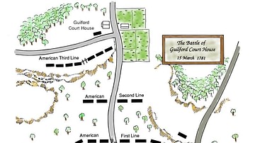
Battle of Guilford Court House, Battle Map

Battle of Brandywine Map

Battle of Germantown Map
Cite This Work
APA Style
Denis, L. (2025, May 23). Map of the Rhine From Strasbourg to Mainz. World History Encyclopedia. Retrieved from https://www.worldhistory.org/image/20472/map-of-the-rhine-from-strasbourg-to-mainz/
Chicago Style
Denis, Léopold. "Map of the Rhine From Strasbourg to Mainz." World History Encyclopedia. Last modified May 23, 2025. https://www.worldhistory.org/image/20472/map-of-the-rhine-from-strasbourg-to-mainz/.
MLA Style
Denis, Léopold. "Map of the Rhine From Strasbourg to Mainz." World History Encyclopedia. World History Encyclopedia, 23 May 2025, https://www.worldhistory.org/image/20472/map-of-the-rhine-from-strasbourg-to-mainz/. Web. 30 Jun 2025.