


The Bosporan Kingdom (c. 480 BCE–341 CE) emerged around the Cimmerian Bosporus (modern Kerch Strait) as a hybrid Greco-local state founded by Greek colonists from cities such as Miletus. Rather than a single unified polity in the modern sense, it developed as a network of coastal cities, agricultural hinterlands, and allied territories linking the northern Black Sea to the wider Greek world. Early rule under the Archaeanactid dynasty (c. 480–438 BCE) gave way to the Spartocid dynasty (438–110 BCE), which consolidated authority and transformed the kingdom into a major supplier of grain, fish, timber, and slaves, particularly to the Aegean. Positioned between steppe and sea, the Bosporan state functioned as a key intermediary zone of exchange, where Greek urban culture interacted with Scythian and other local traditions.
In the late Hellenistic period, the kingdom became entangled in the ambitions of Mithridates VI of Pontus (reign 120–63 BCE) before emerging as a Roman client state by the mid-1st century BCE. Under rulers such as Tiberius Julius Aspurgus (reign 8 BCE–38 CE), a dynastic line developed that blended Greek and local identities, reflecting the region’s role as a cultural crossroads. Supported by Rome yet retaining internal autonomy, the kingdom prospered for several centuries as part of the wider Black Sea economic system. From the 3rd century CE onward, however, increasing pressure from groups such as the Goths and Alans, followed by the Huns in the 370s CE, destabilized the region. By 341 CE, the Bosporan Kingdom had ceased to exist as an independent political entity, marking the end of one of the longest-lasting states of the ancient Black Sea world.
About the Author

Related Images

Map of the Hanseatic League Trade Network, c. 1400
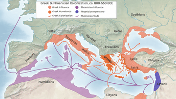
Greek and Phoenician Colonization

Map of the Empire of the Huns under Attila, c. 450 CE - Power, Pressure, and Collapse in Late Antiquity

Phoenician Trade Network
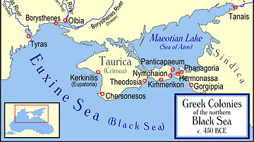
Greek Colonies of the Northern Black Sea

Map of the Trade Networks of the Roman Empire - Commerce & the Connectivity in the Mediterranean 1-3 c. CE
Cite This Work
APA Style
Netchev, S. (2026, March 31). Map of the Bosporan Kingdom, c.100 CE: Gateway Between Steppe, Caucasus, and Rome. World History Encyclopedia. https://www.worldhistory.org/image/19765/map-of-the-bosporan-kingdom-c100-ce/
Chicago Style
Netchev, Simeon. "Map of the Bosporan Kingdom, c.100 CE: Gateway Between Steppe, Caucasus, and Rome." World History Encyclopedia, March 31, 2026. https://www.worldhistory.org/image/19765/map-of-the-bosporan-kingdom-c100-ce/.
MLA Style
Netchev, Simeon. "Map of the Bosporan Kingdom, c.100 CE: Gateway Between Steppe, Caucasus, and Rome." World History Encyclopedia, 31 Mar 2026, https://www.worldhistory.org/image/19765/map-of-the-bosporan-kingdom-c100-ce/.