
Illustration


This map illustrates the shifting geopolitical landscape of North Africa and the Western Mediterranean in 1065, a pivotal moment marked by fragmentation and the emergence of new powers. As older dynasties weakened, new forces rose across the region, setting the stage for profound political realignments that would reshape the medieval world.
In North Africa, the Hammadid dynasty consolidated power in present-day Algeria after splitting from the Zirids, who faced devastating raids by the Banu Hilal and Banu Sulaym - Arab tribes dispatched by the Fatimid Caliphate to punish the Zirids for embracing Sunni Islam. The resulting upheaval destabilized vast territories and accelerated the decline of the Badicid emirate. Meanwhile, the Almoravids, a Berber confederation from the Sahara, were expanding northward, soon to leave their mark on both Africa and the Iberian Peninsula. In the Mediterranean, the Normans advanced their conquest of Sicily, while the fractured Taifas of al-Andalus struggled against growing internal weakness and external threats.
With sincere thanks and admiration to Boutkhil Tayeb for his inspiration, patience, and fantastic research.
About the Author

Related Images

The Taifa Kingdoms of the Iberian Peninsula, 1031-1086

Norman Conquest of Britain, 1066 - 1086
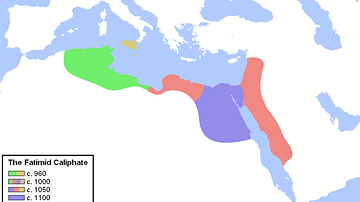
Expansion of the Fatimid Caliphate
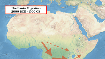
The Bantu Migration in Africa
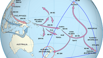
Polynesian Migration Map

Early Human Migration Across the Globe
Cite This Work
APA Style
Netchev, S. (2024, September 12). Map of Medieval North Africa, c. 1065. World History Encyclopedia. Retrieved from https://www.worldhistory.org/image/19431/map-of-medieval-north-africa-c-1065/
Chicago Style
Netchev, Simeon. "Map of Medieval North Africa, c. 1065." World History Encyclopedia. Last modified September 12, 2024. https://www.worldhistory.org/image/19431/map-of-medieval-north-africa-c-1065/.
MLA Style
Netchev, Simeon. "Map of Medieval North Africa, c. 1065." World History Encyclopedia. World History Encyclopedia, 12 Sep 2024, https://www.worldhistory.org/image/19431/map-of-medieval-north-africa-c-1065/. Web. 29 Apr 2025.