


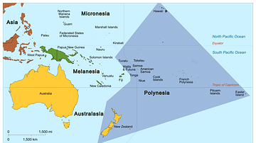
Map showing the migration of Polynesians who it is thought were originally from Taiwan. They settled in the Polynesian Triangle that encompasses New Zealand, Hawaii and Easter Island as its corners. The Polynesians left Taiwan somewhere between 3,000 to 1,000 BCE.
Related Images
Map of Polynesia

Map of the Migration Period in Europe in the 4th-5th Century

Map of Romani Migration in the Middle Ages

The Bantu Migration in Africa

Vandal Migration
Migration of the Cimbri
Cite This Work
APA Style
Eccles, D. (2019, May 19). Polynesian Migration Map. World History Encyclopedia. https://www.worldhistory.org/image/10691/polynesian-migration-map/
Chicago Style
Eccles, David. "Polynesian Migration Map." World History Encyclopedia, May 19, 2019. https://www.worldhistory.org/image/10691/polynesian-migration-map/.
MLA Style
Eccles, David. "Polynesian Migration Map." World History Encyclopedia, 19 May 2019, https://www.worldhistory.org/image/10691/polynesian-migration-map/.