


Hadrian’s Wall was constructed from c. 122 CE onward during the reign of Emperor Hadrian (reign 117–138 CE) as part of a broader imperial strategy to consolidate, rather than endlessly expand, Roman power. Running 73 miles (118 km) across northern Britain from the Tyne to the Solway Firth, the wall marked the formal northern frontier of Roman authority. It did not simply divide Romans from northern peoples, such as later groups identified as Picts, but defined a controlled zone where movement, taxation, and military response could be regulated.
Built and maintained by soldiers from the three Roman legions stationed in Britain, Hadrian’s Wall functioned as a complex frontier system rather than a single barrier. Forts, milecastles, watchtowers, roads, and civilian settlements created a militarized landscape that facilitated surveillance, communication, and supply. Although the frontier briefly shifted north to the Antonine Wall (c. 142–162 CE) under Antoninus Pius (reign 138–161 CE), Hadrian’s Wall remained the empire’s principal northern boundary for much of the 2nd to 4th centuries CE. As both an instrument of control and a statement of imperial presence, the wall embodied Rome’s approach to managing diversity, security, and power at the edges of empire.
About the Author

Related Images

Map of the Roman Rule in Britain c. 43 - 410 CE - Four Centuries of Empire at the Edge of the World
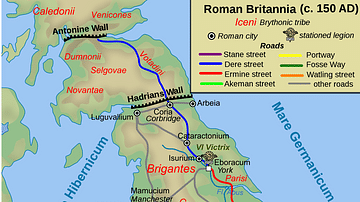
Map of Roman Britain, 150 AD

Map of the Battle of Britain, 1940
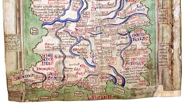
Matthew Paris' Map of Britain

Map of the Norman Conquest of Britain, 1066 - 1086 - From Hastings to Domesday – The Making of Norman England

Trench Warfare on WWI's Western Front, 1914-18
Cite This Work
APA Style
Netchev, S. (2026, January 11). Map of the Hadrian’s wall (Vallum Hadriani) c. 122 CE. World History Encyclopedia. https://www.worldhistory.org/image/16294/map-of-the-hadrians-wall-vallum-hadriani-c-122-ce/
Chicago Style
Netchev, Simeon. "Map of the Hadrian’s wall (Vallum Hadriani) c. 122 CE." World History Encyclopedia, January 11, 2026. https://www.worldhistory.org/image/16294/map-of-the-hadrians-wall-vallum-hadriani-c-122-ce/.
MLA Style
Netchev, Simeon. "Map of the Hadrian’s wall (Vallum Hadriani) c. 122 CE." World History Encyclopedia, 11 Jan 2026, https://www.worldhistory.org/image/16294/map-of-the-hadrians-wall-vallum-hadriani-c-122-ce/.