
Illustration


This map illustrates the rise and territorial expansion of the Neo-Assyrian Empire (circa 911–609 BCE), a dominant Mesopotamian power that emerged after earlier phases of Assyrian history. Unlike their predecessors, Neo-Assyrian kings pursued deliberate and sustained military campaigns aimed at imperial conquest. Through successive reigns, the empire grew into the most extensive political entity the world had seen up to that point.
At its height, the Neo-Assyrian Empire controlled a vast region—from the Taurus Mountains in the north to the Persian Gulf and Arabian desert in the south, and from Egypt and the Levant in the west to the Zagros Mountains in the east. This territory was ruled from a series of centralized capitals in Assyria proper: first Assur, then Kalhu (Nimrud), followed by Dur-Sharrukin, and finally Nineveh. The empire’s power rested on a combination of advanced military organization, siege technology, and a sophisticated bureaucratic system. As a result, many historians regard the Neo-Assyrian Empire not only as the largest of its time but also as the world’s first true empire in terms of scale and centralized administration.
About the Author

Related Images

Map of the World in the 14th Century

Map of Mesopotamia, 2000-1600 BCE

Map of the World from Sippar, Mesopotamia

Map of Mesopotamia and the Ancient Near East, c. 1300 BCE
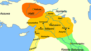
Map of Mesopotamia, c. 1400 BCE
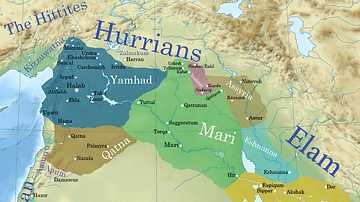
Ancient Syro-Mesopotamia ca. 1764 BCE
Cite This Work
APA Style
Netchev, S. (2022, January 21). Map of the Neo-Assyrian Empire. World History Encyclopedia. Retrieved from https://www.worldhistory.org/image/15148/map-of--the-neo-assyrian-empire/
Chicago Style
Netchev, Simeon. "Map of the Neo-Assyrian Empire." World History Encyclopedia. Last modified January 21, 2022. https://www.worldhistory.org/image/15148/map-of--the-neo-assyrian-empire/.
MLA Style
Netchev, Simeon. "Map of the Neo-Assyrian Empire." World History Encyclopedia. World History Encyclopedia, 21 Jan 2022, https://www.worldhistory.org/image/15148/map-of--the-neo-assyrian-empire/. Web. 25 Jun 2025.