


The Phoenician expansion between the 11th and 6th centuries BCE grew out of the maritime cities of the Levant—most notably Tyre, Sidon, and Byblos, whose skilled sailors and merchants created one of the ancient Mediterranean’s most dynamic trading networks. As these city-states developed advanced shipbuilding and navigational techniques, they extended their commercial reach across Cyprus, the Aegean, North Africa, and the western Mediterranean. Their economy flourished through the exchange of timber, purple dye, metalwork, glass, and luxury goods, linking Near Eastern markets with Greek, Egyptian, and Anatolian spheres.
Over time, this commercial web evolved into a pattern of settlement and colonization. From the 10th century BCE onward, Phoenician communities established outposts and later urban colonies,most famously Carthage (traditionally founded c. 814 BCE, during the reign of Pygmalion of Tyre,) along the coasts of North Africa, Sicily, Sardinia, and the Iberian Peninsula. These colonies served as staging points for trade, cultural exchange, and resource extraction, helping Phoenician influence span thousands of kilometers. By the 6th century BCE, shifting regional powers, including the Neo-Assyrian Empire (c. 911–609 BCE) and the Neo-Babylonian Empire (reign of Nebuchadnezzar II, 605–562 BCE), gradually curtailed Phoenician independence in the Levant. Yet their colonies continued to thrive, carrying forward Phoenician language, religion, and commercial practices long after the homeland fell under imperial domination.
About the Author

Related Images

Map of the Trade Routes in the Ancient Mediterranean

Greek and Phoenician Colonization
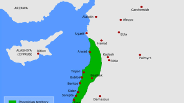
Map of Phoenicia

Map of the Roman Trade Network (1st - 3rd centuries CE)

Map of the Rise and Fall of Carthage (c. 650-146 BCE)

Map of the Expansion of the Roman Republic (c. 260 - 30 BCE)
Cite This Work
APA Style
Netchev, S. (2021, November 09). Map of the Phoenician Expansion c. 11 - 6 centuries BCE. World History Encyclopedia. https://www.worldhistory.org/image/14796/map-of-the-phoenician-expansion-c-11---6-centuries/
Chicago Style
Netchev, Simeon. "Map of the Phoenician Expansion c. 11 - 6 centuries BCE." World History Encyclopedia, November 09, 2021. https://www.worldhistory.org/image/14796/map-of-the-phoenician-expansion-c-11---6-centuries/.
MLA Style
Netchev, Simeon. "Map of the Phoenician Expansion c. 11 - 6 centuries BCE." World History Encyclopedia, 09 Nov 2021, https://www.worldhistory.org/image/14796/map-of-the-phoenician-expansion-c-11---6-centuries/.