


The Da Ming Hunyi Tu is a Chinese world map made c. 1389, during the Ming Dynasty. The map, which replicates the curvature of the Earth, centers on China but also includes Africa and Europe. 386 (151.9 in) x 456 cm (175.9). Paint on silk. First Historical Archive of China, Beijing.
Related Images

Map of the Ming Dynasty of China, 1368-1644

Ming Dynasty Blue-and-White Porcelain

Map of the Ming Dynasty Territory

Ming Dynasty Empire, c. 1409 CE
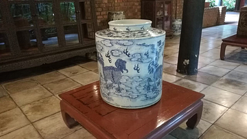
Ming Dynasty Porcelain

Shang Dynasty of China, c. 1100 BCE
Cite This Work
APA Style
Trochos, D. (2021, May 30). Da Ming Hunyi Tu. World History Encyclopedia. https://www.worldhistory.org/image/14131/da-ming-hunyi-tu/
Chicago Style
Trochos, David. "Da Ming Hunyi Tu." World History Encyclopedia, May 30, 2021. https://www.worldhistory.org/image/14131/da-ming-hunyi-tu/.
MLA Style
Trochos, David. "Da Ming Hunyi Tu." World History Encyclopedia, 30 May 2021, https://www.worldhistory.org/image/14131/da-ming-hunyi-tu/.