


Map of the former Carolingian Empire in 898 following its collapse in 887 as a result of the deposition of Emperor Charles the Fat (r. 876-887). The kingdoms were claimed by various regional nobles, each of whom contested the imperial title. By 898, West Francia (red) was ruled by Charles the Simple (r. 893-923), East Francia (green) by Emperor Arnulf of Carinthia (r. 887-899), Burgundy (purple) by Rudolf I of Burgundy (r. 888-912), and Provence (orange) by Louis the Blind (r. 887-928). Italy was contested by Lambert II of Spoleto (pink; r. 891-898) And Berengar I of Friuli (teal; r. 888-924). The Papal States (yellow) remained independent.
Related Images

Emperor Charles the Fat & King Louis III the Younger of East Francia
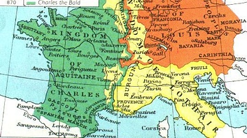
Division of the Carolingian Empire in 843 & 870 CE

Lothaire Bluteau as Charles of West Francia & Morgane Polanski as Gisela

Lothaire Bluteau as Charles of West Francia
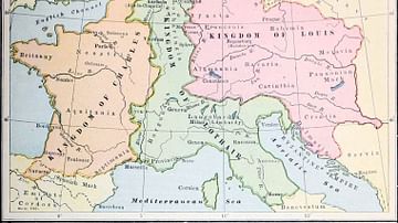
Division of the Carolingian Empire
France During the Reign of Charles the Simple
Cite This Work
APA Style
Trasamundo. (2021, May 18). Division of the Carolingian Empire in 898. World History Encyclopedia. https://www.worldhistory.org/image/14037/division-of-the-carolingian-empire-in-898/
Chicago Style
Trasamundo. "Division of the Carolingian Empire in 898." World History Encyclopedia, May 18, 2021. https://www.worldhistory.org/image/14037/division-of-the-carolingian-empire-in-898/.
MLA Style
Trasamundo. "Division of the Carolingian Empire in 898." World History Encyclopedia, 18 May 2021, https://www.worldhistory.org/image/14037/division-of-the-carolingian-empire-in-898/.